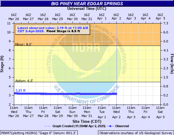
Big Piney near Edgar Springs
Critical Stages
4.5' - Action
8.5' - Flood
Moderate
Major
Latest Observation
Updated: 8:00 AM CST 12/6/25
Status: No Flooding
Stage: 2.71 ft
Flow: 0.238 kcfs
Forecast
Forecast not available for this location.
| Time | Stage (ft) | Flow (kcfs) |
|---|---|---|
| 8:00 AM 12/6 | 2.71 | 0.238 |
| 7:45 AM 12/6 | 2.71 | 0.238 |
| 7:30 AM 12/6 | 2.71 | 0.238 |
| 7:15 AM 12/6 | 2.71 | 0.238 |
| 7:00 AM 12/6 | 2.71 | 0.238 |
| 6:45 AM 12/6 | 2.71 | 0.238 |
| 6:30 AM 12/6 | 2.71 | 0.238 |
| 6:15 AM 12/6 | 2.71 | 0.238 |
| 6:00 AM 12/6 | 2.71 | 0.238 |
| 5:45 AM 12/6 | 2.72 | 0.24 |
| 5:30 AM 12/6 | 2.71 | 0.238 |
| 5:15 AM 12/6 | 2.71 | 0.238 |
| 5:00 AM 12/6 | 2.72 | 0.24 |
| 4:45 AM 12/6 | 2.72 | 0.24 |
| 4:30 AM 12/6 | 2.72 | 0.24 |
| 4:15 AM 12/6 | 2.72 | 0.24 |
| 4:00 AM 12/6 | 2.72 | 0.24 |
| 3:45 AM 12/6 | 2.72 | 0.24 |
| 3:30 AM 12/6 | 2.72 | 0.24 |
| 3:15 AM 12/6 | 2.72 | 0.24 |
| 3:00 AM 12/6 | 2.72 | 0.24 |
| 2:45 AM 12/6 | 2.72 | 0.24 |
| 2:30 AM 12/6 | 2.72 | 0.24 |
| 2:15 AM 12/6 | 2.72 | 0.24 |
| 2:00 AM 12/6 | 2.72 | 0.24 |
| 1:45 AM 12/6 | 2.72 | 0.24 |
| 1:30 AM 12/6 | 2.72 | 0.24 |
| 1:15 AM 12/6 | 2.72 | 0.24 |
| 1:00 AM 12/6 | 2.72 | 0.24 |
| 12:45 AM 12/6 | 2.72 | 0.24 |
30.67' -
This is the crest level on April 30, 2017.
29.8' -
The river gage equipment floods. Data will likely be lost.
29.45' -
Crest Level of Nov 2024. I-44 inundated approx 29.5 miles ds.
24.5' -
This is the crest level December 4, 1982.
| Date | Stage (ft) |
|---|---|
| Apr 30, 2017 | 30.67 |
| Nov 5, 2024 | 29.45 |
| Dec 4, 1982 | 24.5 |
| Mar 19, 2008 | 23.58 |
| Dec 29, 2015 | 23.18 |
| Dec 27, 1942 | 20.7 |
| May 9, 2002 | 20.6 |
| Aug 6, 2013 | 20.31 |
| Nov 15, 1993 | 19.81 |
| May 16, 1956 | 19.8 |
| Sep 26, 1993 | 19.66 |
| Mar 11, 1935 | 19.62 |
| May 25, 1946 | 19.53 |
| Jul 11, 2015 | 19.37 |
| Jan 30, 1969 | 19.28 |
| Apr 15, 1945 | 19.08 |
| Feb 10, 1966 | 19.01 |
| Apr 25, 1947 | 19 |
| Mar 25, 2023 | 18.91 |
| Jan 12, 2020 | 18.87 |
Data provided by the National Weather Service.