Little Arkansas River near Halstead
Critical Stages
24' - Action
25' - Flood
27' - Moderate
29' - Major
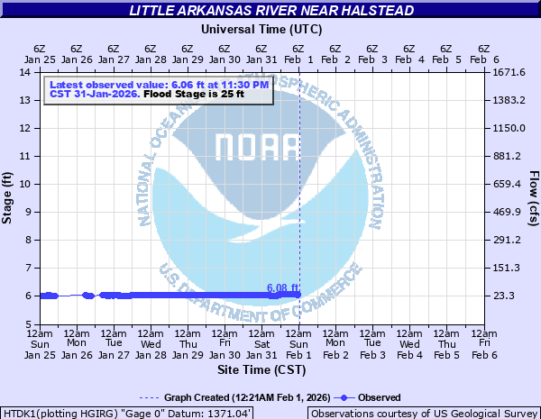
Latest Observation
Updated: 11:30 AM CST 12/15/25
Status: No Flooding
Stage: 6.04 ft
Flow: 0.0023 kcfs
Forecast
Forecast not available for this location.
| Time | Stage (ft) | Flow (kcfs) |
|---|---|---|
| 11:30 AM 12/15 | 6.04 | 0.0023 |
| 11:15 AM 12/15 | 6.05 | 0.0031 |
| 11:00 AM 12/15 | 6.05 | 0.0031 |
| 10:45 AM 12/15 | 6.05 | 0.0031 |
| 10:30 AM 12/15 | 6.05 | 0.0031 |
| 10:15 AM 12/15 | 6.05 | 0.0031 |
| 10:00 AM 12/15 | 6.05 | 0.0031 |
| 9:45 AM 12/15 | 6.06 | 0.0041 |
| 9:30 AM 12/15 | 6.06 | 0.0041 |
| 9:15 AM 12/15 | 6.06 | 0.0041 |
| 9:00 AM 12/15 | 6.06 | 0.0041 |
| 8:45 AM 12/15 | 6.06 | 0.0041 |
| 8:30 AM 12/15 | 6.06 | 0.0041 |
| 8:15 AM 12/15 | 6.07 | 0.0054 |
| 8:00 AM 12/15 | 6.07 | 0.0054 |
| 7:45 AM 12/15 | 6.07 | 0.0054 |
| 7:30 AM 12/15 | 6.07 | 0.0054 |
| 7:15 AM 12/15 | 6.07 | 0.0054 |
| 7:00 AM 12/15 | 6.07 | 0.0054 |
| 6:45 AM 12/15 | 6.08 | 0.0072 |
| 6:30 AM 12/15 | 6.08 | 0.0072 |
| 6:15 AM 12/15 | 6.08 | 0.0072 |
| 6:00 AM 12/15 | 6.08 | 0.0072 |
| 5:45 AM 12/15 | 6.08 | 0.0072 |
| 5:30 AM 12/15 | 6.08 | 0.0072 |
| 5:15 AM 12/15 | 6.08 | 0.0072 |
| 5:00 AM 12/15 | 6.08 | 0.0072 |
| 4:45 AM 12/15 | 6.08 | 0.0072 |
| 4:30 AM 12/15 | 6.08 | 0.0072 |
| 4:15 AM 12/15 | 6.08 | 0.0072 |
27' -
Flood water covers the westbound lane of Highway 50 at mile marker 262. Flooding inundates Halstead Road on the north end of city and on K89 or Hertzler Road leading into Halstead from the north. Flood gates on west end of Halstead will be closed. The second flood gate by the railroad on the east side of Halstead closes around 27.2 feet.
26.8' -
Flood waters cover K89 to an expansion of 1500 ft. The depth of water is about 2 to 3 inches. There is a considerable amount of cropland flooding. Water is over Halstead Road near an automotive business which is located 1/2 mile north of city. Flood waters flow across the road at about 3 inches in depth and expands across the road about 10 ft across. The Little Arkansas River will be about 1 1/2 feet below the bridge grider on Halstead Road.
26' -
Riverside Park floods north of the river. Flood waters may begin to encroach on K89 just north of the river bridge along with a trailer park and a few residences north of Halstead. Expect field flooding on both sides of Halstead Road north of the flood gates. More field flooding occurs north of Highway 50 on the east bank of the river. Just southeast of the city, SW 48th St becomes impassable from Hertzler Rd to Essex Heights.
25' -
Expect cropland and field flooding near the river.
| Date | Stage (ft) |
|---|---|
| May 25, 2007 | 27.22 |
| Nov 2, 1998 | 27.13 |
| May 9, 2019 | 27.12 |
| May 23, 2019 | 27.09 |
| Aug 8, 2013 | 26.95 |
| Jul 5, 2016 | 26.72 |
| May 30, 1995 | 26.68 |
| Mar 26, 2000 | 26.4 |
| Oct 10, 2018 | 26.29 |
| Jun 26, 2019 | 26.28 |
| Jul 6, 2010 | 26.23 |
| Jul 30, 2013 | 26.12 |
| Jun 20, 2025 | 26.05 |
| Mar 6, 2004 | 26.03 |
| Aug 15, 2013 | 25.81 |
| Oct 10, 2003 | 25.78 |
| Dec 15, 2015 | 25.64 |
| May 28, 2019 | 25.61 |
| May 29, 2016 | 25.15 |
| May 11, 2009 | 24.99 |
Data provided by the National Weather Service.