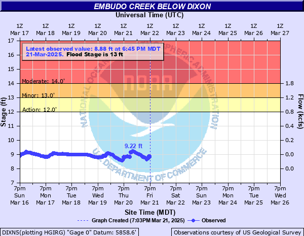
Embudo Creek below Dixon
Critical Stages
12' - Action
13' - Flood
14' - Moderate
17' - Major
Latest Observation
Updated: 2:45 AM MST 12/16/25
Status: No Flooding
Stage: 9.16 ft
Flow: 0.0356 kcfs
Forecast
Forecast not available for this location.
| Time | Stage (ft) | Flow (kcfs) |
|---|---|---|
| 2:45 AM 12/16 | 9.16 | 0.0356 |
| 2:30 AM 12/16 | 9.16 | 0.0356 |
| 2:15 AM 12/16 | 9.16 | 0.0356 |
| 2:00 AM 12/16 | 9.17 | 0.0364 |
| 1:45 AM 12/16 | 9.17 | 0.0364 |
| 1:30 AM 12/16 | 9.18 | 0.0373 |
| 1:15 AM 12/16 | 9.18 | 0.0373 |
| 1:00 AM 12/16 | 9.2 | 0.039 |
| 12:45 AM 12/16 | 9.2 | 0.039 |
| 12:30 AM 12/16 | 9.2 | 0.039 |
| 12:15 AM 12/16 | 9.21 | 0.0397 |
| 12:00 AM 12/16 | 9.21 | 0.0397 |
| 11:45 PM 12/15 | 9.21 | 0.0397 |
| 11:30 PM 12/15 | 9.21 | 0.0397 |
| 11:15 PM 12/15 | 9.2 | 0.039 |
| 11:00 PM 12/15 | 9.21 | 0.0397 |
| 10:45 PM 12/15 | 9.21 | 0.0397 |
| 10:30 PM 12/15 | 9.21 | 0.0397 |
| 10:15 PM 12/15 | 9.22 | 0.0405 |
| 10:00 PM 12/15 | 9.22 | 0.0405 |
| 9:45 PM 12/15 | 9.23 | 0.0413 |
| 9:30 PM 12/15 | 9.23 | 0.0413 |
| 9:15 PM 12/15 | 9.23 | 0.0413 |
| 9:00 PM 12/15 | 9.24 | 0.042 |
| 8:45 PM 12/15 | 9.22 | 0.0405 |
| 8:30 PM 12/15 | 9.2 | 0.039 |
| 8:15 PM 12/15 | 9.19 | 0.0381 |
| 8:00 PM 12/15 | 9.17 | 0.0364 |
| 7:45 PM 12/15 | 9.16 | 0.0356 |
| 7:30 PM 12/15 | 9.16 | 0.0356 |
15' -
The Embudo Station building and the few nearby upstream homes along the Rio Grande banks at Embudo are subject to serious flooding. Parts of the State Road 570 from Pilar to the Taos Junction bridge are inundated and impassable. The Pilar bridge off State Road 570 has water flowing over it. Lowland flooding is extensive from above Pilar downstream to Espanola.
12' -
Patio of Embudo Station building on the west bank begins to flood. The few homes along the river near the restaurant and upstream are in danger of becoming flooded if further rises occur. The suspended wooden bridge over the Rio Grande between Embudo and Pilar linking homes on the west bank with State Road 68 is closed as water is flowing over the center section of the bridge. Water covers part of the State Road 570 between Pilar and the Taos Junction Bridge.
10' -
Access to riverside picnic facilities above Pilar but below the Taos Junction bridge unavailable. Water is about to flow over the center section of the low swinging bridge upstream used by local residents who live on the west side of the river.
8' -
Overflow to small farms upstream and downstream of gage, particularly in the area 1 to 3 miles above the gage. Access to riverside picnic facilities above Pilar and below the Taos Junction bridge becomes affected. The overflow may cause problems to low swinging bridges upstream and affect access roads to small farms.
| Date | Stage (ft) |
|---|---|
| Aug 1, 2010 | 10.8 |
| Aug 29, 1977 | 7.1 |
| Aug 22, 1946 | 7 |
| Jun 28, 1943 | 6.8 |
| Jul 24, 1989 | 5.94 |
| May 22, 1991 | 5.78 |
| Jun 9, 1979 | 5.4 |
| Jul 10, 1975 | 5.29 |
| May 20, 1994 | 4.94 |
| Jul 8, 1998 | 4.54 |
| May 24, 2005 | 4.54 |
| May 25, 1999 | 4.39 |
Data provided by the National Weather Service.