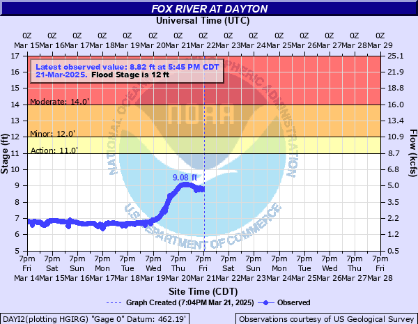
Fox River at Dayton
Critical Stages
11' - Action
12' - Flood
14' - Moderate
24' - Major
Latest Observation
Updated: 12:45 AM CST 12/16/25
Status: No Flooding
Stage: 6.15 ft
Flow: 1.34 kcfs
Forecast
Forecast not available for this location.
| Time | Stage (ft) | Flow (kcfs) |
|---|---|---|
| 12:45 AM 12/16 | 6.15 | 1.34 |
| 12:30 AM 12/16 | 6.14 | 1.34 |
| 12:15 AM 12/16 | 6.15 | 1.34 |
| 12:00 AM 12/16 | 6.16 | 1.35 |
| 11:45 PM 12/15 | 6.18 | 1.37 |
| 11:30 PM 12/15 | 6.19 | 1.38 |
| 11:15 PM 12/15 | 6.19 | 1.38 |
| 11:00 PM 12/15 | 6.2 | 1.39 |
| 10:45 PM 12/15 | 6.34 | 1.52 |
| 10:30 PM 12/15 | 6.29 | 1.48 |
| 10:15 PM 12/15 | 6.23 | 1.42 |
| 10:00 PM 12/15 | 6.2 | 1.39 |
| 9:45 PM 12/15 | 6.17 | 1.36 |
| 9:30 PM 12/15 | 6.17 | 1.36 |
| 9:15 PM 12/15 | 6.12 | 1.32 |
| 9:00 PM 12/15 | 6.14 | 1.34 |
| 8:45 PM 12/15 | 6.1 | 1.3 |
| 8:30 PM 12/15 | 6.08 | 1.28 |
| 8:15 PM 12/15 | 6.12 | 1.32 |
| 8:00 PM 12/15 | 6.33 | 1.51 |
| 7:45 PM 12/15 | 6.23 | 1.42 |
| 7:30 PM 12/15 | 6.12 | 1.32 |
| 7:15 PM 12/15 | 6.16 | 1.35 |
| 7:00 PM 12/15 | 6.16 | 1.35 |
| 6:45 PM 12/15 | 6.1 | 1.3 |
| 6:30 PM 12/15 | 6.13 | 1.33 |
| 6:15 PM 12/15 | 6.11 | 1.31 |
| 6:00 PM 12/15 | 6.09 | 1.29 |
| 5:45 PM 12/15 | 6.14 | 1.34 |
| 5:30 PM 12/15 | 6.06 | 1.27 |
26' -
Residential structures threatened off Dayton Road in Dayton.
23' -
Numerous residential structures threatened along 2959th Road between Ottawa and Dayton. Industrial structures threatened in Wedron.
22' -
Illinois Railway tracks threatened in Wedron. Campgrounds may be threatened near Sheridan.
21.5' -
2153rd Road threatened in Wedron.
20' -
Roadways and structures may be threatened in Millington.
19.5' -
A few residential structures threatened along 2959th Road between Ottawa and Dayton.
19' -
42nd Road may be threatened north of Sheridan.
17.5' -
Agricultural land inundated near Sheridan.
17' -
2603rd Road may be threatened north of Sheridan.
16' -
Multiple structures may be threatened north of Sheridan.
14.5' -
Low-lying agricultural land inundated near Norway.
14' -
Residential structures threatened along 2059th Road south of Wedron.
13' -
Residential structures threatened along 2062nd Road in Wedron. Water overflows low-lying banks in Dayton and Ottawa.
12.5' -
2062nd Road threatened in Wedron. Low-lying agricultural land inundated near Wedron.
12' -
Water overflows low-lying banks in Wedron and Sheridan.
| Date | Stage (ft) |
|---|---|
| Jan 25, 1960 | 36.47 |
| Jan 30, 1952 | 32.04 |
| Jan 10, 1973 | 32 |
| Oct 11, 1954 | 24.63 |
| Jul 19, 1996 | 24.47 |
| Feb 21, 1966 | 22.81 |
| Jan 26, 1969 | 22.51 |
| Feb 11, 1974 | 22.18 |
| Sep 14, 2008 | 21.48 |
| Feb 22, 1997 | 21.46 |
| Apr 19, 2013 | 20.7 |
| Feb 27, 1994 | 20.53 |
| Feb 13, 1984 | 19.8 |
| Mar 19, 1948 | 19.65 |
| Feb 24, 1985 | 19.52 |
| Jan 21, 2020 | 18.13 |
| Jan 22, 1916 | 17.7 |
| Jan 17, 2005 | 17.53 |
| Jan 25, 1938 | 17.5 |
| Mar 20, 1979 | 17.35 |
Data provided by the National Weather Service.