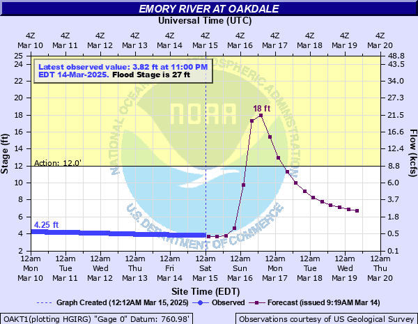
Emory River at Oakdale
Critical Stages
12' - Action
27' - Flood
28' - Moderate
30' - Major
Latest Observation
Updated: 1:00 AM EST 12/15/25
Status: No Flooding
Stage: 3.82 ft
Flow: 0.446 kcfs
Forecast
| Time | Stage (ft) | Flow (kcfs) |
|---|---|---|
| 7 AM 12/15 | 3.9 | 0.474 |
| 1 PM 12/15 | 3.9 | 0.474 |
| 7 PM 12/15 | 3.9 | 0.474 |
| 1 AM 12/16 | 3.9 | 0.474 |
| 7 AM 12/16 | 3.8 | 0.439 |
| 1 PM 12/16 | 3.8 | 0.439 |
| 7 PM 12/16 | 3.8 | 0.439 |
| 1 AM 12/17 | 3.8 | 0.439 |
| 7 AM 12/17 | 3.8 | 0.439 |
| 1 PM 12/17 | 3.8 | 0.439 |
| 7 PM 12/17 | 3.7 | 0.405 |
| 1 AM 12/18 | 3.7 | 0.405 |
| 7 AM 12/18 | 3.7 | 0.405 |
| 1 PM 12/18 | 3.7 | 0.405 |
| 7 PM 12/18 | 3.7 | 0.405 |
| 1 AM 12/19 | 3.7 | 0.405 |
| 7 AM 12/19 | 3.7 | 0.405 |
| Time | Stage (ft) | Flow (kcfs) |
|---|---|---|
| 1:00 AM 12/15 | 3.82 | 0.446 |
| 12:45 AM 12/15 | 3.82 | 0.446 |
| 12:30 AM 12/15 | 3.82 | 0.446 |
| 12:15 AM 12/15 | 3.82 | 0.446 |
| 12:00 AM 12/15 | 3.83 | 0.449 |
| 11:45 PM 12/14 | 3.83 | 0.449 |
| 11:30 PM 12/14 | 3.83 | 0.449 |
| 11:15 PM 12/14 | 3.83 | 0.449 |
| 11:00 PM 12/14 | 3.83 | 0.449 |
| 10:45 PM 12/14 | 3.83 | 0.449 |
| 10:30 PM 12/14 | 3.83 | 0.449 |
| 10:15 PM 12/14 | 3.83 | 0.449 |
| 10:00 PM 12/14 | 3.83 | 0.449 |
| 9:45 PM 12/14 | 3.83 | 0.449 |
| 9:30 PM 12/14 | 3.84 | 0.453 |
| 9:15 PM 12/14 | 3.84 | 0.453 |
| 9:00 PM 12/14 | 3.84 | 0.453 |
| 8:45 PM 12/14 | 3.84 | 0.453 |
| 8:30 PM 12/14 | 3.84 | 0.453 |
| 8:15 PM 12/14 | 3.84 | 0.453 |
| 8:00 PM 12/14 | 3.85 | 0.456 |
| 7:45 PM 12/14 | 3.84 | 0.453 |
| 7:30 PM 12/14 | 3.85 | 0.456 |
| 7:15 PM 12/14 | 3.85 | 0.456 |
| 7:00 PM 12/14 | 3.85 | 0.456 |
| 6:45 PM 12/14 | 3.85 | 0.456 |
| 6:30 PM 12/14 | 3.85 | 0.456 |
| 6:15 PM 12/14 | 3.85 | 0.456 |
| 6:00 PM 12/14 | 3.86 | 0.46 |
| 5:45 PM 12/14 | 3.86 | 0.46 |
42.3' -
Flood of record. Catastrophic flooding.
30' -
Homes on Riverview Road are inundated with 5 to 8 feet of water. A few homes on the opposite side of the road might start taking water. Water may reach onto Emory Drive in Harriman.
28' -
Homes on the near side of Riverview Road will have about 5 feet of water in them. Riverview Road is completely impassable in places. In Harriman, expect flooding in the area of Margrave Drive and Southern Railroad, as well as on low spots of W Carter Ave and Riggs Chapel Rd.
27' -
Flooding starts on Riverview Road. Homes (mostly elevated) closest to the river can have up to about 4 feet of water in their ground floors. Some storage sheds flood. Homes on the far side of the street will have some water in the yards.
18' -
Flooding begins of the rural Clifty Creek Road and bridge over Clifty Creek that immediately joins the Emory River there.
12' -
Minor flooding occurs below Riverview Road. No buildings or roads are threatened.
| Date | Stage (ft) |
|---|---|
| Mar 23, 1929 | 42.3 |
| Dec 23, 1990 | 38.71 |
| Mar 23, 1991 | 38.7 |
| May 28, 1973 | 38.68 |
| Dec 30, 1969 | 34.2 |
| Apr 4, 1977 | 34.05 |
| Feb 6, 2020 | 33.88 |
| Dec 1, 1996 | 32.93 |
| Apr 13, 2020 | 31.34 |
| Feb 13, 1948 | 31 |
| Feb 3, 1939 | 30.9 |
| Mar 13, 1975 | 30.46 |
| Mar 21, 1980 | 30.2 |
| Sep 17, 2004 | 30.03 |
| Mar 28, 2021 | 29.87 |
| Mar 23, 1993 | 29.21 |
| Mar 12, 1963 | 29.1 |
| Jan 24, 2002 | 28.85 |
| Nov 29, 2011 | 28.81 |
| Feb 23, 2019 | 28.26 |
Data provided by the National Weather Service.