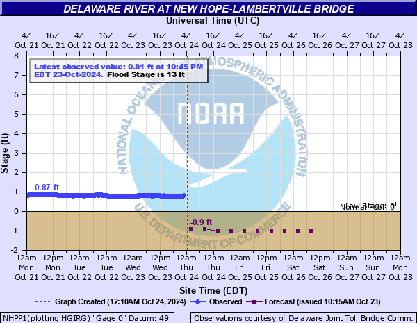
Delaware River at New Hope-Lambertville Bridge
Critical Stages
12' - Action
13' - Flood
15' - Moderate
16' - Major
Latest Observation
Updated: 9:45 AM EST 12/6/25
Status: Low Threshold
Stage: -0.9 ft
Flow: -999 kcfs
Forecast
| Time | Stage (ft) | Flow (kcfs) |
|---|---|---|
| 1 PM 12/6 | -0.9 | -999 |
| 7 PM 12/6 | -0.9 | -999 |
| 1 AM 12/7 | -1 | -999 |
| 7 AM 12/7 | -1 | -999 |
| 1 PM 12/7 | -1 | -999 |
| 7 PM 12/7 | -1.1 | -999 |
| 1 AM 12/8 | -1.1 | -999 |
| 7 AM 12/8 | -1.1 | -999 |
| Time | Stage (ft) | Flow (kcfs) |
|---|---|---|
| 9:45 AM 12/6 | -0.9 | -999 |
| 9:30 AM 12/6 | -0.89 | -999 |
| 9:15 AM 12/6 | -0.89 | -999 |
| 9:00 AM 12/6 | -0.89 | -999 |
| 4:45 AM 12/6 | -0.84 | -999 |
| 4:30 AM 12/6 | -0.84 | -999 |
| 4:15 AM 12/6 | -0.84 | -999 |
| 4:00 AM 12/6 | -0.84 | -999 |
| 2:45 AM 12/6 | -0.83 | -999 |
| 2:30 AM 12/6 | -0.82 | -999 |
| 2:15 AM 12/6 | -0.82 | -999 |
| 2:00 AM 12/6 | -0.82 | -999 |
| 1:45 AM 12/6 | -0.82 | -999 |
| 1:30 AM 12/6 | -0.82 | -999 |
| 1:15 AM 12/6 | -0.82 | -999 |
| 1:00 AM 12/6 | -0.82 | -999 |
| 12:45 AM 12/6 | -0.82 | -999 |
| 12:30 AM 12/6 | -0.82 | -999 |
| 12:15 AM 12/6 | -0.81 | -999 |
| 12:00 AM 12/6 | -0.81 | -999 |
| 12:45 PM 12/5 | -0.81 | -999 |
| 12:30 PM 12/5 | -0.81 | -999 |
| 12:15 PM 12/5 | -0.81 | -999 |
| 12:00 PM 12/5 | -0.81 | -999 |
| 11:45 AM 12/5 | -0.81 | -999 |
| 11:30 AM 12/5 | -0.81 | -999 |
| 11:15 AM 12/5 | -0.81 | -999 |
| 11:00 AM 12/5 | -0.81 | -999 |
| 10:45 AM 12/5 | -0.8 | -999 |
| 10:30 AM 12/5 | -0.8 | -999 |
26' -
Extensive flooding in Lambertville with all of the low-lying areas of town inundated.
17' -
Water is up to the top of the Free Bridge piers.
16.5' -
Water is two-thirds of the way up Coryell Street in Lambertville.
16' -
Water is at the top of the wall in the Waterworks Parking Garage (river side) in New Hope.
15' -
River Road in New Hope begins to flood.
14.5' -
Park floods on East Ferry Street in New Hope. Patio floods in rear of the Landing. Waterview parking gagages in New Hope begin to flood.
14' -
Water covers the entire parking garage at the Waterworks Condominiums in New Hope.
13.5' -
Flooding occurs on Waterloo Street in New Hope via storm sewers.
13' -
Water is at the top of the stone retaining wall at the Landing in New hope. The Waterworks Condominium parking garage in New Hope begins to flood. Residents along the north and south ends of Lambert Lane in Lambertville sustain minor flooding, basements begin to flood.
12.5' -
The lower parking lot begins to flood at the Lambertville Station Inn and Restaurant.
| Date | Stage (ft) |
|---|---|
| Aug 20, 1955 | 24.16 |
| Oct 11, 1903 | 21.8 |
| Apr 4, 2005 | 19.6 |
| Jun 29, 2006 | 19.08 |
| Jan 8, 1841 | 17.9 |
| Mar 19, 1936 | 17.89 |
| Mar 2, 1902 | 17.8 |
| Sep 19, 2004 | 16.5 |
| Mar 15, 1846 | 15.5 |
| Jan 20, 1996 | 15.34 |
| Sep 9, 2011 | 15.1 |
| May 24, 1942 | 14.23 |
| Oct 6, 1786 | 13.9 |
| Sep 2, 2021 | 13.39 |
| May 30, 1984 | 13.21 |
| Dec 12, 1952 | 13.08 |
| Mar 12, 2011 | 13.07 |
| Aug 29, 2011 | 12.74 |
| Oct 16, 1955 | 12.04 |
Data provided by the National Weather Service.