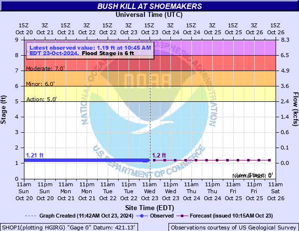
Bush Kill at Shoemakers
Critical Stages
5' - Action
6' - Flood
7' - Moderate
8' - Major
Latest Observation
Updated: 9:45 AM EST 12/6/25
Status: No Flooding
Stage: 1.58 ft
Flow: 0.0434 kcfs
Forecast
| Time | Stage (ft) | Flow (kcfs) |
|---|---|---|
| 1 PM 12/6 | 1.4 | 0.024 |
| 7 PM 12/6 | 1.4 | 0.024 |
| 1 AM 12/7 | 1.4 | 0.024 |
| 7 AM 12/7 | 1.4 | 0.024 |
| 1 PM 12/7 | 1.4 | 0.024 |
| 7 PM 12/7 | 1.4 | 0.024 |
| 1 AM 12/8 | 1.4 | 0.024 |
| 7 AM 12/8 | 1.4 | 0.024 |
| Time | Stage (ft) | Flow (kcfs) |
|---|---|---|
| 9:45 AM 12/6 | 1.58 | 0.0434 |
| 9:30 AM 12/6 | 1.58 | 0.0434 |
| 9:15 AM 12/6 | 1.57 | 0.0421 |
| 9:00 AM 12/6 | 1.57 | 0.0421 |
| 8:45 AM 12/6 | 1.57 | 0.0421 |
| 8:30 AM 12/6 | 1.56 | 0.0409 |
| 8:15 AM 12/6 | 1.56 | 0.0409 |
| 8:00 AM 12/6 | 1.56 | 0.0409 |
| 7:45 AM 12/6 | 1.56 | 0.0409 |
| 7:30 AM 12/6 | 1.55 | 0.0396 |
| 7:15 AM 12/6 | 1.55 | 0.0396 |
| 7:00 AM 12/6 | 1.55 | 0.0396 |
| 6:45 AM 12/6 | 1.54 | 0.0385 |
| 6:30 AM 12/6 | 1.54 | 0.0385 |
| 6:15 AM 12/6 | 1.54 | 0.0385 |
| 6:00 AM 12/6 | 1.54 | 0.0385 |
| 5:45 AM 12/6 | 1.53 | 0.0373 |
| 5:30 AM 12/6 | 1.53 | 0.0373 |
| 5:15 AM 12/6 | 1.53 | 0.0373 |
| 5:00 AM 12/6 | 1.52 | 0.0362 |
| 4:45 AM 12/6 | 1.52 | 0.0362 |
| 4:30 AM 12/6 | 1.52 | 0.0362 |
| 4:15 AM 12/6 | 1.52 | 0.0362 |
| 4:00 AM 12/6 | 1.51 | 0.0351 |
| 3:45 AM 12/6 | 1.51 | 0.0351 |
| 3:30 AM 12/6 | 1.52 | 0.0362 |
| 3:15 AM 12/6 | 1.52 | 0.0362 |
| 3:00 AM 12/6 | 1.51 | 0.0351 |
| 2:45 AM 12/6 | 1.51 | 0.0351 |
| 2:30 AM 12/6 | 1.51 | 0.0351 |
8' -
Significant flooding occurs in the Delaware Gap National Recreation Area. Damage to infrastructure is likely.
7' -
Creek Road near Route 209 and Bushkill Road floods. Flooding increases on Route 209 and is closed.
6' -
Route 209 in the Delaware Water Gap National Recreation Area floods.
| Date | Stage (ft) |
|---|---|
| Aug 19, 1955 | 13.95 |
| Jul 28, 1969 | 8.36 |
| Apr 3, 2005 | 7.51 |
| Aug 28, 2011 | 7.35 |
| Jun 28, 2006 | 7.31 |
| Sep 18, 2004 | 7.27 |
| Jul 24, 1920 | 7.2 |
| Jan 27, 1996 | 7.01 |
| Mar 18, 1936 | 6.92 |
| Mar 11, 2011 | 6.68 |
| Jan 9, 1978 | 6.67 |
| Sep 2, 2021 | 6.6 |
| Dec 11, 1950 | 6.5 |
| Dec 21, 1974 | 6.34 |
| Aug 23, 2021 | 6.26 |
| Dec 18, 2023 | 6.26 |
| Sep 8, 2011 | 6.16 |
| Dec 25, 2020 | 6.13 |
| Mar 7, 2011 | 6.04 |
| Apr 5, 1984 | 5.65 |
Data provided by the National Weather Service.