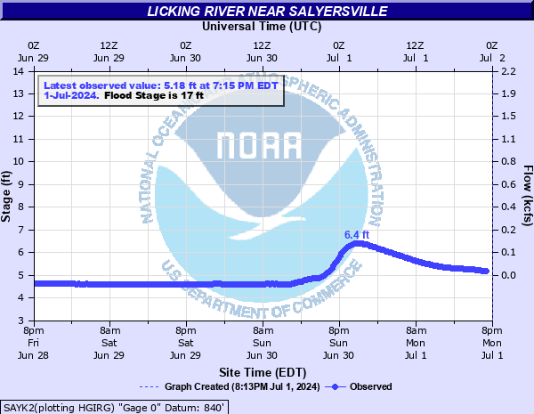
Licking River near Salyersville
Critical Stages
14' - Action
17' - Flood
19' - Moderate
21' - Major
Latest Observation
Updated: 11:15 PM EST 12/14/25
Status: No Flooding
Stage: 5.09 ft
Flow: 0.0196 kcfs
Forecast
Forecast not available for this location.
| Time | Stage (ft) | Flow (kcfs) |
|---|---|---|
| 11:15 PM 12/14 | 5.09 | 0.0196 |
| 11:00 PM 12/14 | 5.1 | 0.02 |
| 10:45 PM 12/14 | 5.1 | 0.02 |
| 10:30 PM 12/14 | 5.1 | 0.02 |
| 10:15 PM 12/14 | 5.1 | 0.02 |
| 10:00 PM 12/14 | 5.1 | 0.02 |
| 9:45 PM 12/14 | 5.1 | 0.02 |
| 9:30 PM 12/14 | 5.11 | 0.0205 |
| 9:15 PM 12/14 | 5.11 | 0.0205 |
| 9:00 PM 12/14 | 5.11 | 0.0205 |
| 8:45 PM 12/14 | 5.12 | 0.0211 |
| 8:30 PM 12/14 | 5.11 | 0.0205 |
| 5:15 PM 12/14 | 5.11 | 0.0205 |
| 5:00 PM 12/14 | 5.11 | 0.0205 |
| 4:45 PM 12/14 | 5.12 | 0.0211 |
| 4:30 PM 12/14 | 5.12 | 0.0211 |
| 4:15 PM 12/14 | 5.1 | 0.02 |
| 4:00 PM 12/14 | 5.1 | 0.02 |
| 3:45 PM 12/14 | 5.1 | 0.02 |
| 3:30 PM 12/14 | 5.1 | 0.02 |
| 3:15 PM 12/14 | 5.1 | 0.02 |
| 3:00 PM 12/14 | 5.1 | 0.02 |
| 2:45 PM 12/14 | 5.11 | 0.0205 |
| 2:30 PM 12/14 | 5.12 | 0.0211 |
| 2:15 PM 12/14 | 5.13 | 0.0216 |
| 2:00 PM 12/14 | 5.12 | 0.0211 |
| 1:45 PM 12/14 | 5.12 | 0.0211 |
| 1:30 PM 12/14 | 5.12 | 0.0211 |
| 1:15 PM 12/14 | 5.12 | 0.0211 |
| 1:00 PM 12/14 | 5.12 | 0.0211 |
21' -
Major flooding occurs.
19' -
Moderate flooding occurs.
17' -
Low lying areas flood.
14' -
Water inundates one lane of Kentucky Highway 1090 in a few places near Lakeville.
| Date | Stage (ft) |
|---|---|
| Feb 3, 1939 | 25.4 |
| Dec 9, 1978 | 24.91 |
| Feb 27, 1962 | 23.7 |
| May 7, 1984 | 23.08 |
| May 31, 2004 | 23.05 |
| Feb 1, 1951 | 22.51 |
| Mar 22, 1952 | 22.41 |
| Feb 14, 1948 | 21.71 |
| Feb 28, 1955 | 21.65 |
| Dec 3, 1991 | 21.51 |
| Nov 28, 1973 | 21.43 |
| Nov 28, 1974 | 21.43 |
| Jun 8, 1981 | 21.3 |
| Jul 6, 1981 | 21.25 |
| Apr 28, 1970 | 21.05 |
| Apr 13, 1948 | 21.04 |
| Aug 5, 1971 | 20.98 |
| Feb 18, 1956 | 20.95 |
| Apr 5, 1977 | 20.91 |
| Mar 7, 1967 | 20.9 |
Data provided by the National Weather Service.