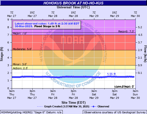
Hohokus Brook at Ho-Ho-Kus
Critical Stages
2.5' - Action
3' - Flood
5' - Moderate
7' - Major
Latest Observation
Updated: 9:30 AM EST 12/6/25
Status: No Flooding
Stage: 1.37 ft
Flow: 0.0187 kcfs
Forecast
Forecast not available for this location.
| Time | Stage (ft) | Flow (kcfs) |
|---|---|---|
| 10:30 AM 12/6 | 1.38 | 0.0194 |
| 10:15 AM 12/6 | 1.38 | 0.0194 |
| 10:00 AM 12/6 | 1.37 | 0.0187 |
| 9:45 AM 12/6 | 1.36 | 0.0179 |
| 9:30 AM 12/6 | 1.37 | 0.0187 |
| 9:15 AM 12/6 | 1.35 | 0.0172 |
| 9:00 AM 12/6 | 1.34 | 0.0165 |
| 8:45 AM 12/6 | 1.34 | 0.0165 |
| 8:30 AM 12/6 | 1.34 | 0.0165 |
| 8:15 AM 12/6 | 1.34 | 0.0165 |
| 8:00 AM 12/6 | 1.34 | 0.0165 |
| 7:45 AM 12/6 | 1.34 | 0.0165 |
| 7:30 AM 12/6 | 1.34 | 0.0165 |
| 7:15 AM 12/6 | 1.34 | 0.0165 |
| 7:00 AM 12/6 | 1.34 | 0.0165 |
| 6:45 AM 12/6 | 1.34 | 0.0165 |
| 6:30 AM 12/6 | 1.35 | 0.0172 |
| 6:15 AM 12/6 | 1.35 | 0.0172 |
| 6:00 AM 12/6 | 1.35 | 0.0172 |
| 5:45 AM 12/6 | 1.35 | 0.0172 |
| 5:30 AM 12/6 | 1.35 | 0.0172 |
| 5:15 AM 12/6 | 1.35 | 0.0172 |
| 5:00 AM 12/6 | 1.35 | 0.0172 |
| 4:45 AM 12/6 | 1.36 | 0.0179 |
| 4:30 AM 12/6 | 1.36 | 0.0179 |
| 4:15 AM 12/6 | 1.37 | 0.0187 |
| 4:00 AM 12/6 | 1.37 | 0.0187 |
| 3:45 AM 12/6 | 1.36 | 0.0179 |
| 3:30 AM 12/6 | 1.37 | 0.0187 |
| 3:15 AM 12/6 | 1.37 | 0.0187 |
7' -
Franklin turnpike is flooded from Maple Avenue to Hollywood Avenue. Major flooding occurs on Marshall Street, warren place, east Glen Avenue and east Ridgewood Road. Hollywood Avenue near north franklin turnpike is flooded with 1 foot of water.
5' -
Flooding of around 6 inches on Hollywood Avenue near north franklin turnpike.
3' -
Flooding only affects park areas.
| Date | Stage (ft) |
|---|---|
| Sep 16, 1999 | 7.32 |
| Nov 8, 1977 | 7.06 |
| Aug 28, 2011 | 6.71 |
| Apr 15, 2007 | 5.33 |
| Apr 5, 1984 | 5.26 |
| Mar 11, 2011 | 4.74 |
| Aug 28, 1971 | 4.7 |
| Aug 19, 1955 | 4.5 |
| Feb 2, 1973 | 4.21 |
| Oct 8, 2005 | 4.2 |
| Nov 28, 1993 | 3.68 |
| Mar 6, 2011 | 3.64 |
| Apr 28, 1980 | 3.4 |
Data provided by the National Weather Service.