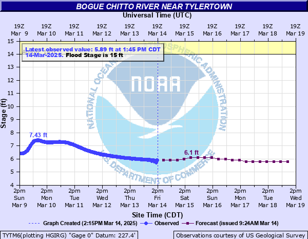
Bogue Chitto River near Tylertown
Critical Stages
14' - Action
15' - Flood
17' - Moderate
23' - Major
Latest Observation
Updated: 4:45 AM CST 12/13/25
Status: No Flooding
Stage: 5.66 ft
Flow: 0.328 kcfs
Forecast
| Time | Stage (ft) | Flow (kcfs) |
|---|---|---|
| 12 PM 12/13 | 5.7 | 0.347 |
| 6 PM 12/13 | 5.7 | 0.347 |
| 12 AM 12/14 | 5.7 | 0.347 |
| 6 AM 12/14 | 5.7 | 0.347 |
| 12 PM 12/14 | 5.7 | 0.347 |
| 6 PM 12/14 | 5.6 | 0.297 |
| 12 AM 12/15 | 5.6 | 0.297 |
| 6 AM 12/15 | 5.6 | 0.297 |
| 12 PM 12/15 | 5.6 | 0.297 |
| 6 PM 12/15 | 5.6 | 0.297 |
| 12 AM 12/16 | 5.6 | 0.297 |
| 6 AM 12/16 | 5.6 | 0.297 |
| 12 PM 12/16 | 5.6 | 0.297 |
| 6 PM 12/16 | 5.6 | 0.297 |
| 12 AM 12/17 | 5.6 | 0.297 |
| 6 AM 12/17 | 5.6 | 0.297 |
| Time | Stage (ft) | Flow (kcfs) |
|---|---|---|
| 4:45 AM 12/13 | 5.66 | 0.328 |
| 4:30 AM 12/13 | 5.66 | 0.328 |
| 4:15 AM 12/13 | 5.66 | 0.328 |
| 4:00 AM 12/13 | 5.66 | 0.328 |
| 3:45 AM 12/13 | 5.66 | 0.328 |
| 3:30 AM 12/13 | 5.67 | 0.333 |
| 3:15 AM 12/13 | 5.66 | 0.328 |
| 3:00 AM 12/13 | 5.67 | 0.333 |
| 2:45 AM 12/13 | 5.66 | 0.328 |
| 2:30 AM 12/13 | 5.67 | 0.333 |
| 2:15 AM 12/13 | 5.67 | 0.333 |
| 2:00 AM 12/13 | 5.67 | 0.333 |
| 1:45 AM 12/13 | 5.67 | 0.333 |
| 1:30 AM 12/13 | 5.67 | 0.333 |
| 1:15 AM 12/13 | 5.67 | 0.333 |
| 1:00 AM 12/13 | 5.67 | 0.333 |
| 12:45 AM 12/13 | 5.67 | 0.333 |
| 12:30 AM 12/13 | 5.67 | 0.333 |
| 12:15 AM 12/13 | 5.67 | 0.333 |
| 12:00 AM 12/13 | 5.67 | 0.333 |
| 11:45 PM 12/12 | 5.67 | 0.333 |
| 11:30 PM 12/12 | 5.67 | 0.333 |
| 11:15 PM 12/12 | 5.67 | 0.333 |
| 11:00 PM 12/12 | 5.68 | 0.339 |
| 10:45 PM 12/12 | 5.67 | 0.333 |
| 10:30 PM 12/12 | 5.68 | 0.339 |
| 10:15 PM 12/12 | 5.68 | 0.339 |
| 10:00 PM 12/12 | 5.68 | 0.339 |
| 9:45 PM 12/12 | 5.68 | 0.339 |
| 9:30 PM 12/12 | 5.68 | 0.339 |
34.7' -
Flood of Record occurred on February 1, 1936.
25' -
There will be extensive flooding of Hidden Springs Resort Park. Homes and secondary roads in the vicinity of the river will remain flooded. There will be widespread flooding of pasture and farm land.
20' -
Secondary roads in the vicinity of the river will flood. Homes close to the river and portions of the Hidden Springs Resort Park will be flooded. There will be widespread flooding of pasture and farm land.
18' -
Secondary roads in the vicinity of the river will flood. Homes close to the river and portions of the Hidden Springs Resort Park will be flooded. Low-lying farm and pasture land near the river will remain flooded.
17' -
Travel in Hidden Springs Resort is possible but hazardous, as roads will be flooded. Evacuation of the park is recommended, when further rises are expected. Low-lying farm and pasture land near the river will remain flooded.
16' -
The road through the middle of Hidden Springs Resort Park will begin to flood along with low-lying farm and pasture land near the river.
15' -
Low-lying farm and pasture land near the river will flood.
| Date | Stage (ft) |
|---|---|
| Feb 1, 1936 | 34.7 |
| Apr 7, 1983 | 34.62 |
| Jan 7, 1950 | 33.5 |
| Apr 14, 1955 | 32.08 |
| Jan 25, 1990 | 31.75 |
| Jan 28, 1994 | 31.25 |
| Apr 14, 1974 | 30.85 |
| Feb 23, 2003 | 30.34 |
| Mar 25, 1973 | 30.07 |
| Aug 31, 2012 | 29.95 |
| May 8, 1975 | 29.69 |
| Aug 22, 1953 | 29.66 |
| Apr 28, 1997 | 28.91 |
| Mar 11, 2016 | 28.91 |
| Oct 5, 1964 | 28.9 |
| Mar 28, 2009 | 28.8 |
| Mar 4, 2001 | 28.72 |
| Dec 7, 1971 | 28.51 |
| Mar 28, 1980 | 28.05 |
| Apr 22, 1977 | 27.51 |
Data provided by the National Weather Service.