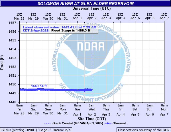
Solomon River at Glen Elder Reservoir
Critical Stages
1478.3' - Action
1488.3' - Flood
Moderate
1495' - Major
Latest Observation
Updated: 1:29 PM CST 12/15/25
Status: No Flooding
Stage: 1451.24 ft
Flow: -999 kcfs
Forecast
Forecast not available for this location.
| Time | Stage (ft) | Flow (kcfs) |
|---|---|---|
| 1:29 PM 12/15 | 1451.24 | -999 |
| 1:14 PM 12/15 | 1451.24 | -999 |
| 12:59 PM 12/15 | 1451.25 | -999 |
| 12:44 PM 12/15 | 1451.25 | -999 |
| 12:29 PM 12/15 | 1451.24 | -999 |
| 12:14 PM 12/15 | 1451.24 | -999 |
| 11:59 AM 12/15 | 1451.24 | -999 |
| 11:44 AM 12/15 | 1451.25 | -999 |
| 11:29 AM 12/15 | 1451.24 | -999 |
| 11:14 AM 12/15 | 1451.25 | -999 |
| 10:59 AM 12/15 | 1451.25 | -999 |
| 10:44 AM 12/15 | 1451.24 | -999 |
| 10:29 AM 12/15 | 1451.24 | -999 |
| 10:14 AM 12/15 | 1451.24 | -999 |
| 9:59 AM 12/15 | 1451.24 | -999 |
| 9:44 AM 12/15 | 1451.25 | -999 |
| 9:29 AM 12/15 | 1451.25 | -999 |
| 9:14 AM 12/15 | 1451.24 | -999 |
| 8:59 AM 12/15 | 1451.23 | -999 |
| 8:44 AM 12/15 | 1451.24 | -999 |
| 7:29 AM 12/15 | 1451.24 | -999 |
| 7:14 AM 12/15 | 1451.24 | -999 |
| 6:59 AM 12/15 | 1451.24 | -999 |
| 6:44 AM 12/15 | 1451.24 | -999 |
| 6:29 AM 12/15 | 1451.24 | -999 |
| 6:14 AM 12/15 | 1451.24 | -999 |
| 5:59 AM 12/15 | 1451.25 | -999 |
| 5:44 AM 12/15 | 1451.24 | -999 |
| 5:29 AM 12/15 | 1451.24 | -999 |
| 5:14 AM 12/15 | 1451.23 | -999 |
1500' -
This elevation represents the height, or crest, of the dam.
1492.9' -
This elevation represents the maximum surcharge at this reservoir.
1488.3' -
This elevation represents the top of the flood control pool.
1467.4' -
This is the elevation when water begins to flow over the spillway.
1455.6' -
This elevation represents the bottom of the flood control pool.
1428' -
This elevation represents the bottom of the conservation pool.
Historical crest information is not available.
Data provided by the National Weather Service.