« Back to Washington Township Rivers
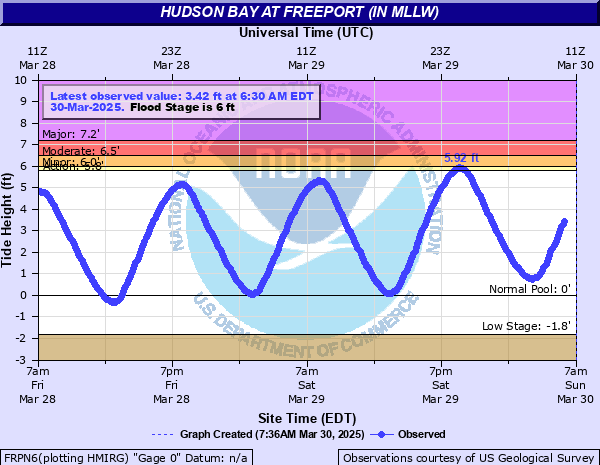
Hudson Bay at Freeport (IN MLLW)
Critical Stages
5.8' - Action
6' - Flood
6.5' - Moderate
7.2' - Major
Latest Observation
Updated: 6:30 PM EST 12/17/25
Status: No Flooding
Stage: 3.48 ft
Flow: -999 kcfs
Forecast
Forecast not available for this location.
| Time | Stage (ft) | Flow (kcfs) |
|---|---|---|
| 6:30 PM 12/17 | 3.48 | -999 |
| 6:24 PM 12/17 | 3.52 | -999 |
| 6:18 PM 12/17 | 3.51 | -999 |
| 6:12 PM 12/17 | 3.54 | -999 |
| 6:06 PM 12/17 | 3.55 | -999 |
| 6:00 PM 12/17 | 3.54 | -999 |
| 5:54 PM 12/17 | 3.53 | -999 |
| 5:48 PM 12/17 | 3.53 | -999 |
| 5:42 PM 12/17 | 3.49 | -999 |
| 5:36 PM 12/17 | 3.46 | -999 |
| 5:30 PM 12/17 | 3.43 | -999 |
| 5:24 PM 12/17 | 3.39 | -999 |
| 5:18 PM 12/17 | 3.34 | -999 |
| 5:12 PM 12/17 | 3.28 | -999 |
| 5:06 PM 12/17 | 3.25 | -999 |
| 5:00 PM 12/17 | 3.19 | -999 |
| 4:54 PM 12/17 | 3.11 | -999 |
| 4:48 PM 12/17 | 3.05 | -999 |
| 4:42 PM 12/17 | 3 | -999 |
| 4:36 PM 12/17 | 2.93 | -999 |
| 4:30 PM 12/17 | 2.83 | -999 |
| 4:24 PM 12/17 | 2.77 | -999 |
| 4:18 PM 12/17 | 2.71 | -999 |
| 4:12 PM 12/17 | 2.66 | -999 |
| 4:06 PM 12/17 | 2.54 | -999 |
| 4:00 PM 12/17 | 2.49 | -999 |
| 3:54 PM 12/17 | 2.4 | -999 |
| 3:48 PM 12/17 | 2.32 | -999 |
| 3:42 PM 12/17 | 2.23 | -999 |
| 3:36 PM 12/17 | 2.16 | -999 |
5' -
5.0 NGVD Hudson Avenue 2 1/2 feet under water. All streets south Atlantic Avenue under water.
4.7' -
4.7 to 4.8 NGVD Guy Lombardo Avenue under water.
| Date | Stage (ft) |
|---|---|
| Oct 29, 2012 | 10.12 |
| Aug 28, 2011 | 7.35 |
| Apr 16, 2007 | 5.67 |
| Oct 18, 2009 | 5.53 |
| Apr 16, 2011 | 5.47 |
| Dec 12, 2008 | 5.45 |
| Dec 1, 2006 | 5.42 |
| Oct 17, 2009 | 5.41 |
| Apr 15, 2007 | 5.41 |
| Oct 25, 2005 | 5.38 |
Data provided by the National Weather Service.