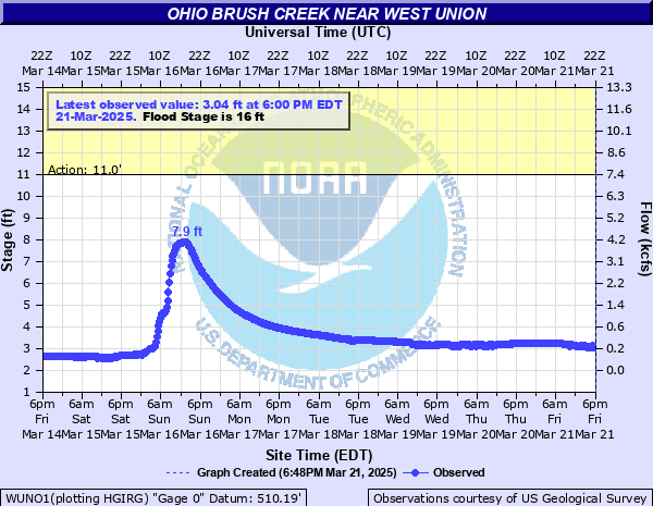
Ohio Brush Creek near West Union
Critical Stages
11' - Action
16' - Flood
24' - Moderate
29' - Major
Latest Observation
Updated: 11:00 PM EST 12/4/25
Status: No Flooding
Stage: 2.58 ft
Flow: 0.104 kcfs
Forecast
Forecast not available for this location.
| Time | Stage (ft) | Flow (kcfs) |
|---|---|---|
| 12:00 AM 12/5 | 2.58 | 0.104 |
| 11:45 PM 12/4 | 2.58 | 0.104 |
| 11:30 PM 12/4 | 2.58 | 0.104 |
| 11:15 PM 12/4 | 2.58 | 0.104 |
| 11:00 PM 12/4 | 2.58 | 0.104 |
| 10:45 PM 12/4 | 2.58 | 0.104 |
| 10:30 PM 12/4 | 2.58 | 0.104 |
| 10:15 PM 12/4 | 2.58 | 0.104 |
| 10:00 PM 12/4 | 2.58 | 0.104 |
| 9:45 PM 12/4 | 2.58 | 0.104 |
| 9:30 PM 12/4 | 2.58 | 0.104 |
| 9:15 PM 12/4 | 2.58 | 0.104 |
| 9:00 PM 12/4 | 2.58 | 0.104 |
| 8:45 PM 12/4 | 2.58 | 0.104 |
| 8:30 PM 12/4 | 2.58 | 0.104 |
| 8:15 PM 12/4 | 2.58 | 0.104 |
| 8:00 PM 12/4 | 2.58 | 0.104 |
| 7:45 PM 12/4 | 2.58 | 0.104 |
| 7:30 PM 12/4 | 2.58 | 0.104 |
| 7:15 PM 12/4 | 2.58 | 0.104 |
| 7:00 PM 12/4 | 2.58 | 0.104 |
| 6:45 PM 12/4 | 2.58 | 0.104 |
| 6:30 PM 12/4 | 2.58 | 0.104 |
| 6:15 PM 12/4 | 2.58 | 0.104 |
| 6:00 PM 12/4 | 2.58 | 0.104 |
| 5:45 PM 12/4 | 2.58 | 0.104 |
| 5:30 PM 12/4 | 2.58 | 0.104 |
| 5:15 PM 12/4 | 2.58 | 0.104 |
| 5:00 PM 12/4 | 2.58 | 0.104 |
| 4:45 PM 12/4 | 2.58 | 0.104 |
33' -
The entire valley along Ohio Brush Creek is flooded. This stage would exceed the flood of record of 31.15 feet. Long stretches of Route 348 in Tiffin and Brush Creek Townships are underwater, as well as several secondary roads in the valley. Water begins to cover the Route 125 Bridge east of West Union, with low sections of Route 125 already covered. Low-lying homes and businesses near West Union become flooded.
31.2' -
Major flooding occurs along State Route 348 and Starley Gustin Road in Tiffin and Brush Creek Townships. This is the flood of record.
31' -
Much of the Ohio Brush Creek valley is inundated, including portions of Route 348 in Tiffin and Brush Creek Townships. Water approaches the bottom of the Route 125 Bridge east of West Union.
27' -
Flooding continues along low areas of State Route 125, and low areas along Route 348 continue to flood. Waggoner Riffle Road and Copas Road also become flooded in areas. Some homes along the creek incur water damage.
25' -
The valley area is filled near Ohio Brush Creek. About a 20 mile section on Route 348 is covered, with several homes and farms affected. Water is also on Route 125 near West Union.
22' -
In addition to flooding of several county and township roads over one foot deep, especially near Lawshe, the lower end of Compton Hill incurs minor flooding.
20' -
Water rises over the east side of State Route 348 south of Cedar Mills, with lowland flooding of county roads especially near Lawshee and west of Peebles.
18' -
Water continues to spill onto Route 348, while several county or township roads near Lawshe and low areas east of West Union near the creek are flooded.
17.5' -
High water on some low-lying county roads is about one foot deep, especially along Satterfield Road in Tiffin township. Other low lying roadways are closed or impassible due to high water.
17' -
Flooding occurs along State Route 348 near Compton Hill Road.
16' -
Flooding of lowland areas continues. A few inches of water is over the creek side lanes of low-lying county roads near the creek close to Lawshee.
| Date | Stage (ft) |
|---|---|
| Mar 2, 1997 | 31.15 |
| Mar 10, 1964 | 27.91 |
| Mar 19, 1943 | 26.5 |
| Mar 19, 1932 | 26 |
| Mar 6, 1945 | 25.3 |
| Sep 9, 2018 | 24.79 |
| Feb 19, 2000 | 24.5 |
| May 16, 1996 | 24 |
| Mar 5, 1962 | 23 |
| May 11, 2003 | 22.45 |
| May 3, 2011 | 22.07 |
| Feb 14, 1948 | 21.93 |
| Mar 1, 2021 | 21.56 |
| Mar 5, 1964 | 21.42 |
| Feb 7, 2019 | 21.2 |
| Mar 4, 2008 | 20.91 |
| May 22, 2010 | 20.67 |
| Feb 22, 1971 | 20.67 |
| Feb 18, 2022 | 20.57 |
| May 22, 2010 | 20.41 |
Data provided by the National Weather Service.