« Back to Westwood Village Rivers
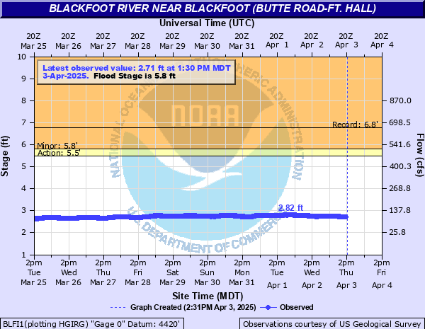
Blackfoot River near Blackfoot (Butte Road-Ft. Hall)
Critical Stages
5.5' - Action
5.8' - Flood
Moderate
Major
Latest Observation
Updated: 6:30 AM MST 12/16/25
Status: No Flooding
Stage: 2.43 ft
Flow: 0.067 kcfs
Forecast
Forecast not available for this location.
| Time | Stage (ft) | Flow (kcfs) |
|---|---|---|
| 6:30 AM 12/16 | 2.43 | 0.067 |
| 6:15 AM 12/16 | 2.44 | 0.068 |
| 6:00 AM 12/16 | 2.44 | 0.068 |
| 5:45 AM 12/16 | 2.46 | 0.07 |
| 5:30 AM 12/16 | 2.44 | 0.068 |
| 5:15 AM 12/16 | 2.46 | 0.07 |
| 5:00 AM 12/16 | 2.47 | 0.072 |
| 4:45 AM 12/16 | 2.49 | 0.074 |
| 4:30 AM 12/16 | 2.47 | 0.072 |
| 4:15 AM 12/16 | 2.49 | 0.074 |
| 4:00 AM 12/16 | 2.49 | 0.074 |
| 3:45 AM 12/16 | 2.5 | 0.075 |
| 3:30 AM 12/16 | 2.49 | 0.074 |
| 3:15 AM 12/16 | 2.5 | 0.075 |
| 3:00 AM 12/16 | 2.51 | 0.077 |
| 2:45 AM 12/16 | 2.51 | 0.077 |
| 2:30 AM 12/16 | 2.51 | 0.077 |
| 2:15 AM 12/16 | 2.51 | 0.077 |
| 2:00 AM 12/16 | 2.5 | 0.075 |
| 1:45 AM 12/16 | 2.49 | 0.074 |
| 1:30 AM 12/16 | 2.5 | 0.075 |
| 1:15 AM 12/16 | 2.49 | 0.074 |
| 1:00 AM 12/16 | 2.48 | 0.073 |
| 12:45 AM 12/16 | 2.46 | 0.07 |
| 12:30 AM 12/16 | 2.48 | 0.073 |
| 12:15 AM 12/16 | 2.46 | 0.07 |
| 12:00 AM 12/16 | 2.44 | 0.068 |
| 11:45 PM 12/15 | 2.42 | 0.065 |
| 11:30 PM 12/15 | 2.44 | 0.068 |
| 11:15 PM 12/15 | 2.42 | 0.065 |
5.8' -
Lowland flooding possible from Interstate 15 to confluence of the Snake River. Homes and cattle operation near Riverton Road (900 W) bridge just north of Ferry Butte Road (500 S) will start to have water seeping near them. Other locations will have water approaching roadways between 550 W and Blackhawk Road.
5.5' -
Nearing bankfull from near Blackfoot downstream to the confluence with the Snake River.
| Date | Stage (ft) |
|---|---|
| Jun 16, 1997 | 6.77 |
| Jun 7, 1976 | 6.73 |
| Apr 18, 2017 | 6.19 |
| Jun 12, 1984 | 5.53 |
| May 29, 2019 | 5.23 |
| Oct 18, 2020 | 4.37 |
| May 16, 2018 | 4.32 |
| Oct 19, 2021 | 3.79 |
Data provided by the National Weather Service.