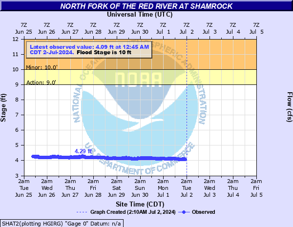
North Fork of the Red River at Shamrock
Critical Stages
9' - Action
10' - Flood
13' - Moderate
20' - Major
Latest Observation
Updated: 4:45 PM CST 12/15/25
Status: No Flooding
Stage: 5.24 ft
Flow: 0.0034 kcfs
Forecast
Forecast not available for this location.
| Time | Stage (ft) | Flow (kcfs) |
|---|---|---|
| 4:45 PM 12/15 | 5.24 | 0.0034 |
| 4:30 PM 12/15 | 5.25 | 0.0036 |
| 4:15 PM 12/15 | 5.26 | 0.0039 |
| 4:00 PM 12/15 | 5.26 | 0.0039 |
| 3:45 PM 12/15 | 5.26 | 0.0039 |
| 3:30 PM 12/15 | 5.26 | 0.0039 |
| 3:15 PM 12/15 | 5.26 | 0.0039 |
| 3:00 PM 12/15 | 5.26 | 0.0039 |
| 2:45 PM 12/15 | 5.24 | 0.0034 |
| 2:30 PM 12/15 | 5.22 | 0.003 |
| 2:15 PM 12/15 | 5.22 | 0.003 |
| 2:00 PM 12/15 | 5.21 | 0.0028 |
| 1:45 PM 12/15 | 5.21 | 0.0028 |
| 1:30 PM 12/15 | 5.21 | 0.0028 |
| 1:15 PM 12/15 | 5.21 | 0.0028 |
| 1:00 PM 12/15 | 5.2 | 0.0026 |
| 12:45 PM 12/15 | 5.19 | 0.0024 |
| 12:30 PM 12/15 | 5.2 | 0.0026 |
| 12:15 PM 12/15 | 5.19 | 0.0024 |
| 12:00 PM 12/15 | 5.19 | 0.0024 |
| 11:45 AM 12/15 | 5.19 | 0.0024 |
| 11:30 AM 12/15 | 5.2 | 0.0026 |
| 11:15 AM 12/15 | 5.19 | 0.0024 |
| 11:00 AM 12/15 | 5.19 | 0.0024 |
| 10:45 AM 12/15 | 5.2 | 0.0026 |
| 10:30 AM 12/15 | 5.19 | 0.0024 |
| 10:15 AM 12/15 | 5.19 | 0.0024 |
| 10:00 AM 12/15 | 5.2 | 0.0026 |
| 8:45 AM 12/15 | 5.16 | 0.002 |
| 8:30 AM 12/15 | 5.15 | 0.0017 |
31' -
Road surface of hwy 83 bridge flooded.
24' -
Water reaches bottom of hwy 83 bridge.
20' -
Widespread farm and ranch land flooding occurs. Losses to cattle likely. Losses to farm equipment and structures possible.
13' -
Significant farm and ranch land flooding occurs. Cattle and farm equipment losses are possible.
10' -
Water begins to spread out over the 0.2 mile floodplain. Cattle grazing in flood plain should have access to higher ground. Minor farm land flooding begins to occur a few miles downstream from gage site.
| Date | Stage (ft) |
|---|---|
| May 1, 1957 | 21.1 |
| Jun 3, 1995 | 13.49 |
| May 29, 1974 | 12.47 |
| May 20, 1977 | 11.16 |
| Jun 2, 2024 | 10.31 |
| May 23, 2015 | 10.15 |
| Jun 19, 2008 | 9.07 |
| May 25, 2010 | 8.99 |
| Apr 22, 2010 | 8.96 |
Data provided by the National Weather Service.