« Back to Wildhorse Golf Club At Robson Ranch Rivers
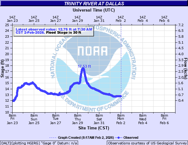
Trinity River at Dallas
Critical Stages
29' - Action
30' - Flood
38' - Moderate
40' - Major
Latest Observation
Updated: 6:30 AM CST 12/6/25
Status: No Flooding
Stage: 13.28 ft
Flow: 0.844 kcfs
Forecast
Forecast not available for this location.
| Time | Stage (ft) | Flow (kcfs) |
|---|---|---|
| 6:30 AM 12/6 | 13.28 | 0.844 |
| 6:15 AM 12/6 | 13.3 | 0.852 |
| 6:00 AM 12/6 | 13.3 | 0.852 |
| 5:45 AM 12/6 | 13.26 | 0.836 |
| 5:30 AM 12/6 | 13.26 | 0.836 |
| 5:15 AM 12/6 | 13.26 | 0.836 |
| 5:00 AM 12/6 | 13.26 | 0.836 |
| 4:45 AM 12/6 | 13.27 | 0.84 |
| 4:30 AM 12/6 | 13.27 | 0.84 |
| 4:15 AM 12/6 | 13.27 | 0.84 |
| 4:00 AM 12/6 | 13.28 | 0.844 |
| 3:45 AM 12/6 | 13.28 | 0.844 |
| 3:30 AM 12/6 | 13.29 | 0.848 |
| 3:15 AM 12/6 | 13.29 | 0.848 |
| 3:00 AM 12/6 | 13.3 | 0.852 |
| 2:45 AM 12/6 | 13.32 | 0.86 |
| 2:30 AM 12/6 | 13.25 | 0.832 |
| 2:15 AM 12/6 | 13.26 | 0.836 |
| 2:00 AM 12/6 | 13.26 | 0.836 |
| 1:45 AM 12/6 | 13.26 | 0.836 |
| 1:30 AM 12/6 | 13.26 | 0.836 |
| 1:15 AM 12/6 | 13.25 | 0.832 |
| 1:00 AM 12/6 | 13.27 | 0.84 |
| 12:45 AM 12/6 | 13.27 | 0.84 |
| 12:30 AM 12/6 | 13.27 | 0.84 |
| 12:15 AM 12/6 | 13.28 | 0.844 |
| 12:00 AM 12/6 | 13.27 | 0.84 |
| 11:45 PM 12/5 | 13.28 | 0.844 |
| 11:30 PM 12/5 | 13.28 | 0.844 |
| 11:15 PM 12/5 | 13.29 | 0.848 |
62' -
The levees near downtown will be topped, and widespread significant flooding can be expected thoughout Dallas.
48' -
The area around the old procter and gamble plant will flood. Persons along the river and in flood prone areas should expect much higher water than normal.
47' -
Industries along the river south of dallas will be flooded.
43.5' -
Major flooding of industrial areas in south dallas can be expected. Oxichem warehouses in south dallas begins flooding.
42' -
The S.L. & S.W. Railroad and Santa Fe railroad bridges in South Dallas flood.
41' -
Major flooding is expected both upstream and downstream from the gage. Dallas city packing 4 miles downstream starts to flood.Old Forest Avenue bridge closed. Water reaches the foundation of the Oxichem plant 6 miles south of Commerce St.
40' -
Major flooding will occur in Dallas along the river between the levees.
38' -
Moderate flooding is expected along the river both above and below the Commerce Street bridge. Significant flooding is expected along the bike trails and parks along the river.
35' -
Minor flooding is expected along the river. Bike trails along the river will experience significant flooding, and the Trammel Crow Park parking lot below the Sylvan bridge will have floodwaters several feet deep.
33' -
Minor flooding along the river is expected. Bike trails along the river will have floodwaters several feet deep, and the parking lot of Trammel Crow Park beneath the Sylvan bridge will flood.
32' -
Minor flooding along the river will occur, and bike trails along the river will be flooded with up to 2 feet of water.
30' -
Minor lowland flooding will begin, and trails along the river begin to flood.
| Date | Stage (ft) |
|---|---|
| May 25, 1908 | 52.6 |
| May 3, 1990 | 47.1 |
| May 18, 1949 | 46.93 |
| Apr 26, 1942 | 45.56 |
| Dec 20, 1991 | 44.44 |
| May 17, 1989 | 43.31 |
| Jun 12, 1941 | 42.9 |
| Apr 27, 1922 | 42.35 |
| May 20, 1935 | 42.1 |
| May 29, 2015 | 41.98 |
| May 26, 1957 | 41.72 |
| Sep 9, 2010 | 41.39 |
| Feb 19, 1938 | 41.15 |
| Mar 20, 2006 | 41.12 |
| Nov 28, 2015 | 41.08 |
| Mar 31, 1945 | 40.96 |
| May 8, 1969 | 40.68 |
| Jun 2, 1946 | 40.6 |
| Feb 27, 1948 | 40.5 |
| Sep 23, 2018 | 40.42 |
Data provided by the National Weather Service.