« Back to Wildhorse Golf Club At Robson Ranch Rivers
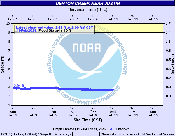
Denton Creek near Justin
Critical Stages
9' - Action
10' - Flood
15' - Moderate
17' - Major
Latest Observation
Updated: 7:00 AM CST 12/6/25
Status: No Flooding
Stage: 2.55 ft
Flow: 0.0149 kcfs
Forecast
Forecast not available for this location.
| Time | Stage (ft) | Flow (kcfs) |
|---|---|---|
| 6:00 AM 12/6 | 2.55 | 0.0149 |
| 5:45 AM 12/6 | 2.55 | 0.0149 |
| 5:30 AM 12/6 | 2.56 | 0.0153 |
| 5:15 AM 12/6 | 2.58 | 0.0161 |
| 5:00 AM 12/6 | 2.56 | 0.0153 |
| 4:45 AM 12/6 | 2.55 | 0.0149 |
| 4:30 AM 12/6 | 2.55 | 0.0149 |
| 4:15 AM 12/6 | 2.55 | 0.0149 |
| 4:00 AM 12/6 | 2.56 | 0.0153 |
| 3:45 AM 12/6 | 2.55 | 0.0149 |
| 3:30 AM 12/6 | 2.55 | 0.0149 |
| 3:15 AM 12/6 | 2.55 | 0.0149 |
| 3:00 AM 12/6 | 2.56 | 0.0153 |
| 2:45 AM 12/6 | 2.56 | 0.0153 |
| 2:30 AM 12/6 | 2.56 | 0.0153 |
| 2:15 AM 12/6 | 2.55 | 0.0149 |
| 2:00 AM 12/6 | 2.55 | 0.0149 |
| 1:45 AM 12/6 | 2.55 | 0.0149 |
| 1:30 AM 12/6 | 2.55 | 0.0149 |
| 1:15 AM 12/6 | 2.55 | 0.0149 |
| 1:00 AM 12/6 | 2.56 | 0.0153 |
| 12:45 AM 12/6 | 2.56 | 0.0153 |
| 12:30 AM 12/6 | 2.55 | 0.0149 |
| 12:15 AM 12/6 | 2.55 | 0.0149 |
| 12:00 AM 12/6 | 2.55 | 0.0149 |
| 11:45 PM 12/5 | 2.55 | 0.0149 |
| 11:30 PM 12/5 | 2.56 | 0.0153 |
| 11:15 PM 12/5 | 2.57 | 0.0157 |
| 11:00 PM 12/5 | 2.55 | 0.0149 |
| 10:45 PM 12/5 | 2.57 | 0.0157 |
21.6' -
Major out of banks flooding will occur. Most rural roads near the creek will flood. Farm and ranch lands along the creek will be well underwater.
20.6' -
Major out of banks flooding will occur. Farm and ranch roads, as well as rural roads along the creek, will be well underwater.
17' -
Major out of bank flooding will occur. Tim Donald Rd south of the creek will be covered by 2 to 3 feet of water. Ranch land south of the creek will be submerged by a few feet of water.
16' -
Moderate out of bank flooding will occur. Tim Donald Rd south of the creek will be covered by 1 to 2 feet of water. Ranch land south of the creek will be inundated.
15' -
Moderate out of bank flooding starts. Water starts to cover portions of FM 407 north of the creek and Tim Donald Rd south of the creek.
10' -
Minor out of bank flooding will occur to farm and ranch lands near the creek.
| Date | Stage (ft) |
|---|---|
| Jan 1, 1908 | 21.6 |
| May 1, 1935 | 20.6 |
| May 24, 1957 | 17.64 |
| Apr 26, 1990 | 17.26 |
| Apr 26, 1957 | 17.2 |
| Oct 31, 1974 | 17.1 |
| May 2, 1958 | 16.7 |
| Sep 7, 1962 | 16.68 |
| Oct 13, 1981 | 16.68 |
| Jun 7, 1989 | 16.57 |
| Mar 18, 2020 | 16.48 |
| Mar 27, 1977 | 16.37 |
| May 1, 1966 | 16.16 |
| Jun 23, 1959 | 16.08 |
| May 6, 1969 | 16.05 |
| May 28, 1987 | 16.03 |
| Feb 24, 2001 | 15.97 |
| Dec 20, 1991 | 15.95 |
| Feb 20, 1997 | 15.93 |
| Feb 16, 2001 | 15.75 |
Data provided by the National Weather Service.