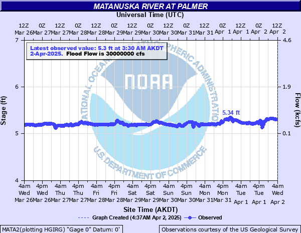
Matanuska River at Palmer
Critical Stages
Action
Flood
Moderate
Major
Latest Observation
Updated: 2:30 PM AKST 11/14/25
Status: Out Of Service
Stage: 1.26 ft
Flow: 7.1 kcfs
Forecast
Forecast not available for this location.
| Time | Stage (ft) | Flow (kcfs) |
|---|---|---|
| 6:30 AM 12/10 | -9999 | -999 |
| 6:15 AM 12/10 | -9999 | -999 |
| 6:00 AM 12/10 | -9999 | -999 |
| 5:45 AM 12/10 | -9999 | -999 |
| 5:30 AM 12/10 | -9999 | -999 |
| 5:15 AM 12/10 | -9999 | -999 |
| 5:00 AM 12/10 | -9999 | -999 |
| 4:45 AM 12/10 | -9999 | -999 |
| 4:30 AM 12/10 | -9999 | -999 |
| 4:15 AM 12/10 | -9999 | -999 |
| 4:00 AM 12/10 | -9999 | -999 |
| 3:45 AM 12/10 | -9999 | -999 |
| 3:30 AM 12/10 | -9999 | -999 |
| 3:15 AM 12/10 | -9999 | -999 |
| 3:00 AM 12/10 | -9999 | -999 |
| 2:45 AM 12/10 | -9999 | -999 |
| 2:30 AM 12/10 | -9999 | -999 |
| 2:15 AM 12/10 | -9999 | -999 |
| 2:00 AM 12/10 | -9999 | -999 |
| 1:45 AM 12/10 | -9999 | -999 |
| 1:30 AM 12/10 | -9999 | -999 |
| 1:15 AM 12/10 | -9999 | -999 |
| 1:00 AM 12/10 | -9999 | -999 |
| 12:45 AM 12/10 | -9999 | -999 |
| 12:30 AM 12/10 | -9999 | -999 |
| 12:15 AM 12/10 | -9999 | -999 |
| 12:00 AM 12/10 | -9999 | -999 |
| 11:45 PM 12/9 | -9999 | -999 |
| 11:30 PM 12/9 | -9999 | -999 |
| 11:15 PM 12/9 | -9999 | -999 |
35000' -
Moderate Flood Flow - This discharge (flow) level has a roughly 10 percent chance of being reached in any given year. Flooding near vulnerable locations along the active river channel may become more significant and widespread. This level was reached during the flooding in 2012.
30000' -
Minor Flood Flow - This discharge (flow) level has a roughly 20 percent chance of being reached in any given year. Additional vulnerable locations near the active river channel may experience some flooding at this level west of the Old Glenn Highway in the Butte and near Sutton from Milepost 64 to 66. Residents are advised that for the past several years at both of these locations, the main channel of the river has been shifting closer to the bank.
15000' -
Action Flow - This discharge (flow) level represents the higher end of the typical summertime range, and will likely be reached at least once nearly every year. Localized minor out-of-bank flooding may start to occur along parts of the Glenn highway, especially east of Sutton from milepost 64 to 66.
| Date | Stage (ft) |
|---|---|
| Aug 10, 1971 | 13.6 |
| Jun 21, 2004 | 13.34 |
| Sep 22, 1995 | 13.04 |
| Jun 20, 1999 | 12.6 |
| Aug 13, 2003 | 12.37 |
| Jul 11, 1949 | 12.03 |
| Jul 18, 2002 | 11.51 |
| Jun 8, 1964 | 11.45 |
| Aug 23, 1963 | 11.4 |
| Jul 6, 2000 | 11.28 |
| Jun 29, 2001 | 11.24 |
| Jul 25, 1950 | 11.18 |
| Jun 14, 1972 | 11.05 |
| Jun 8, 1951 | 11 |
| Jun 20, 1957 | 10.9 |
| Aug 24, 1959 | 10.82 |
| Jun 11, 2018 | 10.81 |
| Sep 21, 2012 | 10.78 |
| Jun 15, 1973 | 10.67 |
| Jun 17, 2005 | 10.54 |
Data provided by the National Weather Service.