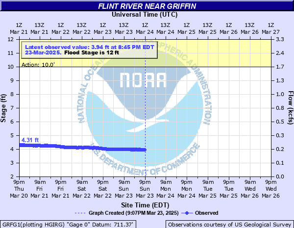
Flint River near Griffin
Critical Stages
10' - Action
12' - Flood
17' - Moderate
20' - Major
Latest Observation
Updated: 12:45 PM EST 12/9/25
Status: No Flooding
Stage: 3.09 ft
Flow: 0.104 kcfs
Forecast
Forecast not available for this location.
| Time | Stage (ft) | Flow (kcfs) |
|---|---|---|
| 12:45 PM 12/9 | 3.09 | 0.104 |
| 12:30 PM 12/9 | 3.1 | 0.105 |
| 12:15 PM 12/9 | 3.09 | 0.104 |
| 12:00 PM 12/9 | 3.09 | 0.104 |
| 11:45 AM 12/9 | 3.09 | 0.104 |
| 11:30 AM 12/9 | 3.08 | 0.103 |
| 11:15 AM 12/9 | 3.09 | 0.104 |
| 11:00 AM 12/9 | 3.08 | 0.103 |
| 10:45 AM 12/9 | 3.08 | 0.103 |
| 10:30 AM 12/9 | 3.08 | 0.103 |
| 10:15 AM 12/9 | 3.08 | 0.103 |
| 10:00 AM 12/9 | 3.07 | 0.102 |
| 9:45 AM 12/9 | 3.07 | 0.102 |
| 9:30 AM 12/9 | 3.08 | 0.103 |
| 9:15 AM 12/9 | 3.07 | 0.102 |
| 9:00 AM 12/9 | 3.07 | 0.102 |
| 8:45 AM 12/9 | 3.08 | 0.103 |
| 8:30 AM 12/9 | 3.08 | 0.103 |
| 8:15 AM 12/9 | 3.07 | 0.102 |
| 8:00 AM 12/9 | 3.08 | 0.103 |
| 7:45 AM 12/9 | 3.08 | 0.103 |
| 7:30 AM 12/9 | 3.08 | 0.103 |
| 7:15 AM 12/9 | 3.08 | 0.103 |
| 7:00 AM 12/9 | 3.08 | 0.103 |
| 6:45 AM 12/9 | 3.08 | 0.103 |
| 6:30 AM 12/9 | 3.08 | 0.103 |
| 6:15 AM 12/9 | 3.08 | 0.103 |
| 6:00 AM 12/9 | 3.09 | 0.104 |
| 5:45 AM 12/9 | 3.09 | 0.104 |
| 5:30 AM 12/9 | 3.09 | 0.104 |
33' -
Major flooding expands upstream and downstream from Georgia Highway 16, 9 or more feet higher than July 1994. The bridge on Highway 16 is completely overtopped. The USGS gage house located on the bridge will be submerged and data transmission loss will be likely.
30' -
Major flooding expands upstream and downstream from Georgia Highway 16, higher than July 1994. The fire station will be innundated with several feet of water. Water reaches the road surface of the Highway 16 bridge and may cause damage to the structure. Wildcat Creek continues to flood a large section of West Ellis Road up to 13 feet deep. Significant flooding will continue along West Ellis Road and may impact up to a dozen homes.
25' -
Major flooding expands upstream and downstream from Georgia Highway 16, higher than July 1994. Flood waters continue to innundate the fire station and touch the bottom of the bridge. Officials may close the bridge. Portions of Highway 16 will also be flooded. Wildcat Creek continues to flood a large section of West Ellis Road up to 8 feet deep. The homes along Landing Way will experience significant flooding up to 10 feet.
23' -
Major flooding expands upstream and downstream from Georgia Highway 16. Flood waters begin to innundate the fire station and reaches the bottom of the bridge. Officials may close the bridge. Wildcat Creek continues to flood a portion of West Ellis Road around 6 feet deep. The backyards of homes at the end of Landing Way will be under 10 feet of water and innundate homes.
22' -
Major flooding expands upstream and downstream from Georgia Highway 16. Flood waters approach the doors of the fire station. Wildcat Creek backs up and floods a portion of West Ellis Road around 5 feet deep. The backyards of homes at the end of Landing Way will be under 9 feet of water and innundate homes.
20' -
Major flooding begins upstream and downstream from Georgia Highway 16. Flood waters approach the foundation of a fire station. Wildcat Creek backs up and floods a portion of West Ellis Road around 3 feet deep. The backyards of homes at the end of Landing Way will be under 7 feet of water and few homes begin to flood.
19' -
Moderate flooding expands. Significant flooding expands upstream and downstream from Georgia Highway 16. Flood waters spread to the fire station parking lot. Wildcat Creek backs up and floods a portion of West Ellis Road around two feet deep. The backyards of homes at the end of Landing Way will be flooded around 6 feet deep with water close to entering a few homes.
18' -
Moderate flooding expands. Significant flooding occurs upstream and downstream from Georgia Highway 16. The recycling center behind the fire station will be flooded with 1 to 2 feet of water. Wildcat Creek backs up and floods a portion of West Ellis Road near one foot deep. The backyards of homes at the end of Landing Way will be under 5 feet of water and surrounds the foundations of a few homes.
17' -
Moderate flooding begins. Significant flooding occurs upstream and downstream from Georgia Highway 16. The recycling center behind the fire station will begin to flood. Wildcat Creek upstream will backup and begin to flood a portion of West Ellis Road. The backyards of homes at the end of Landing Way will be under 4 feet of water. The flood waters will reach the foundations of a few homes and be under the wooden decks.
16' -
Minor flooding expands further into the woodlands, fields, and pasture upstream and downstream from the gage on Georgia Highway 16 or Newnan Road. The backyards of homes at the end of Landing Way upstream from the bridge will be flooded with around 3 feet of water.
15' -
Minor flooding expands further into the woodlands, fields, and pasture upstream and downstream from the gage on Georgia Highway 16 or Newnan Road. The backyards of homes at the end of Landing Way upstream from the bridge will be flooded with around two feet of water.
14' -
Minor flooding expands into the woodlands, fields, and pasture upstream and downstream from the gage on Georgia Highway 16 or Newnan Road. The backyards of homes at the end of Landing Way upstream from the bridge will be flooded with around one foot of water.
13' -
Minor flooding continues in the woodlands, fields, and pasture upstream and downstream from the gage on Georgia Highway 16 or Newnan Road. The backyards of homes at the end of Landing Way upstream from the bridge will begin to flood.
12' -
Flood stage is reached. Minor flooding begins in the woodlands, fields, and pasture upstream and downstream from the gage on Georgia Highway 16 or Newnan Road.
10' -
Bankfull conditions occur along the river upstream and downstream from the gage at Georgia Highway 16 or Newnan Road.
| Date | Stage (ft) |
|---|---|
| Jul 6, 1994 | 24.22 |
| Nov 27, 1948 | 18 |
| Dec 26, 2015 | 18 |
| Mar 14, 1929 | 17.9 |
| Jul 12, 2005 | 17.46 |
| Mar 22, 1942 | 17 |
| Sep 28, 2024 | 16.99 |
| Mar 3, 1971 | 16.7 |
| Apr 20, 2019 | 16.38 |
| Mar 17, 1990 | 16.2 |
| Feb 26, 1961 | 16.18 |
| Oct 6, 1995 | 15.89 |
| Mar 9, 1998 | 15.62 |
| Jan 1, 2016 | 14.64 |
| Nov 12, 2009 | 14.17 |
| Mar 27, 2023 | 14.15 |
| Jan 15, 2020 | 13.91 |
| Feb 14, 2025 | 13.73 |
| Feb 7, 2020 | 13.54 |
| Feb 13, 2024 | 13.42 |
Data provided by the National Weather Service.