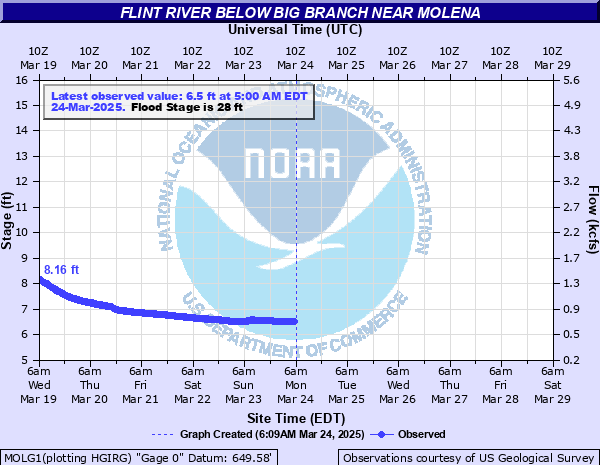
Flint River below Big Branch near Molena
Critical Stages
20' - Action
28' - Flood
33' - Moderate
38' - Major
Latest Observation
Updated: 1:00 PM EST 12/9/25
Status: No Flooding
Stage: 5.46 ft
Flow: 0.339 kcfs
Forecast
Forecast not available for this location.
| Time | Stage (ft) | Flow (kcfs) |
|---|---|---|
| 1:00 PM 12/9 | 5.46 | 0.339 |
| 12:45 PM 12/9 | 5.46 | 0.339 |
| 12:30 PM 12/9 | 5.46 | 0.339 |
| 12:15 PM 12/9 | 5.47 | 0.342 |
| 12:00 PM 12/9 | 5.47 | 0.342 |
| 11:45 AM 12/9 | 5.47 | 0.342 |
| 11:30 AM 12/9 | 5.47 | 0.342 |
| 11:15 AM 12/9 | 5.48 | 0.345 |
| 11:00 AM 12/9 | 5.48 | 0.345 |
| 10:45 AM 12/9 | 5.49 | 0.349 |
| 10:30 AM 12/9 | 5.49 | 0.349 |
| 10:15 AM 12/9 | 5.51 | 0.355 |
| 10:00 AM 12/9 | 5.51 | 0.355 |
| 9:45 AM 12/9 | 5.51 | 0.355 |
| 9:30 AM 12/9 | 5.52 | 0.359 |
| 9:15 AM 12/9 | 5.52 | 0.359 |
| 9:00 AM 12/9 | 5.52 | 0.359 |
| 8:45 AM 12/9 | 5.52 | 0.359 |
| 8:30 AM 12/9 | 5.52 | 0.359 |
| 8:15 AM 12/9 | 5.52 | 0.359 |
| 8:00 AM 12/9 | 5.52 | 0.359 |
| 7:45 AM 12/9 | 5.52 | 0.359 |
| 7:30 AM 12/9 | 5.52 | 0.359 |
| 7:15 AM 12/9 | 5.53 | 0.362 |
| 7:00 AM 12/9 | 5.53 | 0.362 |
| 6:45 AM 12/9 | 5.53 | 0.362 |
| 6:30 AM 12/9 | 5.53 | 0.362 |
| 6:15 AM 12/9 | 5.53 | 0.362 |
| 6:00 AM 12/9 | 5.53 | 0.362 |
| 5:45 AM 12/9 | 5.53 | 0.362 |
38' -
Major flooding begins. Extensive flooding continues to expand into the surrounding areas. Elevated homes near the Georgia Highway 74 bridge will have water reach the floor boards of the houses. Access roads to these homes will be under several feet of water.
33' -
Moderate flooding begins. Flooding continues to expand into the agricultural and wooded areas upstream and downstream from the gage located near the pump station. Significant flooding expands into the agricultural and wooded areas downstream from the gage near the Georgia Highway 74 bridge. Elevated homes in this location will have several feet of water underneath them. Access roads to these homes will be completely flooded.
28' -
Flood stage is reached. Minor flooding of the natural flood plain near the gage location begins. Flooding continues to expand into the agricultural and wooded areas downstream from the gage near the Georgia Highway 74 bridge. Elevated homes in this location will see a foot or two of water underneath them.
24' -
Minor flooding continues in the agricultural and wooded areas downstream from the gage near the Georgia Highway 74 bridge. In this area the water level reaches the foundation of a house on the left bank.
22' -
Minor flooding begins in the agricultural and wooded areas downstream from the gage near the Georgia Highway 74 bridge. In this area water begins to surround a few homes.
20' -
Bankfull conditions are reached along the river from Flat Shoals Road to the Georgia Highway 74 bridge.
| Date | Stage (ft) |
|---|---|
| Dec 26, 2015 | 32.22 |
| Jul 13, 2005 | 31.84 |
| Apr 21, 2019 | 28.64 |
| Mar 28, 2023 | 28.38 |
| Sep 29, 2024 | 28.14 |
Data provided by the National Weather Service.