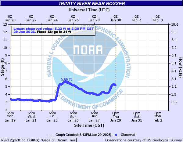
Trinity River near Rosser
Critical Stages
20' - Action
31' - Flood
36' - Moderate
38' - Major
Latest Observation
Updated: 11:30 AM CST 12/7/25
Status: No Flooding
Stage: 3.72 ft
Flow: 1.12 kcfs
Forecast
Forecast not available for this location.
| Time | Stage (ft) | Flow (kcfs) |
|---|---|---|
| 11:30 AM 12/7 | 3.72 | 1.12 |
| 11:15 AM 12/7 | 3.75 | 1.15 |
| 11:00 AM 12/7 | 3.78 | 1.17 |
| 10:45 AM 12/7 | 3.77 | 1.16 |
| 10:30 AM 12/7 | 3.79 | 1.17 |
| 10:15 AM 12/7 | 3.8 | 1.18 |
| 10:00 AM 12/7 | 3.79 | 1.17 |
| 9:45 AM 12/7 | 3.79 | 1.17 |
| 9:30 AM 12/7 | 3.79 | 1.17 |
| 9:15 AM 12/7 | 3.79 | 1.17 |
| 9:00 AM 12/7 | 3.79 | 1.17 |
| 8:45 AM 12/7 | 3.78 | 1.17 |
| 8:30 AM 12/7 | 3.79 | 1.17 |
| 8:15 AM 12/7 | 3.79 | 1.17 |
| 8:00 AM 12/7 | 3.78 | 1.17 |
| 7:45 AM 12/7 | 3.78 | 1.17 |
| 7:30 AM 12/7 | 3.79 | 1.17 |
| 7:15 AM 12/7 | 3.79 | 1.17 |
| 7:00 AM 12/7 | 3.79 | 1.17 |
| 6:45 AM 12/7 | 3.78 | 1.17 |
| 6:30 AM 12/7 | 3.79 | 1.17 |
| 6:15 AM 12/7 | 3.78 | 1.17 |
| 6:00 AM 12/7 | 3.78 | 1.17 |
| 5:45 AM 12/7 | 3.78 | 1.17 |
| 5:30 AM 12/7 | 3.78 | 1.17 |
| 5:15 AM 12/7 | 3.78 | 1.17 |
| 5:00 AM 12/7 | 3.78 | 1.17 |
| 4:45 AM 12/7 | 3.78 | 1.17 |
| 4:30 AM 12/7 | 3.78 | 1.17 |
| 4:15 AM 12/7 | 3.78 | 1.17 |
43' -
Widespread major flooding is expected along the river. The levees will overflow and farm land will be inundated. Rural roads near the river will be underwater.
42' -
Water will be approaching the top of the lowest area of the levee on the ellis county side of the river.
38' -
Major flooding is expected on farm and ranch lands near the river.
36.5' -
Moderate flooding is expected within the levees.
36' -
Moderate flooding is expected along the river but within the levees.
34' -
Minor to moderate flooding of low areas and roads within the levees is expected.
31' -
Minor flooding of farm and ranch land is expected near the river. A few rural roads may be flooded.
| Date | Stage (ft) |
|---|---|
| Feb 21, 1938 | 41.8 |
| Jun 1, 2015 | 41.6 |
| Apr 23, 1942 | 41.55 |
| May 22, 1935 | 40.4 |
| Nov 29, 2015 | 39.85 |
| May 9, 1995 | 39.61 |
| Jun 16, 1941 | 39.51 |
| Jun 4, 1946 | 39.45 |
| Jan 1, 1932 | 38.3 |
| May 21, 1949 | 38.04 |
| May 29, 1957 | 38 |
| May 1, 1922 | 38 |
| May 4, 1990 | 37.88 |
| May 1, 1966 | 36.85 |
| Oct 18, 2018 | 36.84 |
| Mar 21, 2008 | 36.82 |
| Dec 23, 1991 | 36.47 |
| May 19, 1989 | 36.46 |
| Nov 10, 1946 | 36.42 |
| Dec 30, 2015 | 36.34 |
Data provided by the National Weather Service.