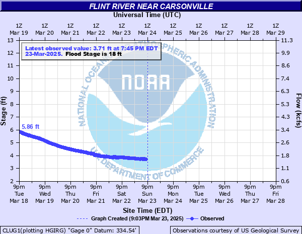
Flint River near Carsonville
Critical Stages
17' - Action
18' - Flood
25' - Moderate
47' - Major
Latest Observation
Updated: 6:45 PM EST 12/15/25
Status: No Flooding
Stage: 2.24 ft
Flow: 0.682 kcfs
Forecast
Forecast not available for this location.
| Time | Stage (ft) | Flow (kcfs) |
|---|---|---|
| 6:45 PM 12/15 | 2.24 | 0.682 |
| 6:30 PM 12/15 | 2.25 | 0.688 |
| 6:15 PM 12/15 | 2.24 | 0.682 |
| 6:00 PM 12/15 | 2.24 | 0.682 |
| 5:45 PM 12/15 | 2.24 | 0.682 |
| 5:30 PM 12/15 | 2.24 | 0.682 |
| 5:15 PM 12/15 | 2.24 | 0.682 |
| 5:00 PM 12/15 | 2.24 | 0.682 |
| 4:45 PM 12/15 | 2.24 | 0.682 |
| 4:30 PM 12/15 | 2.24 | 0.682 |
| 4:15 PM 12/15 | 2.25 | 0.688 |
| 4:00 PM 12/15 | 2.24 | 0.682 |
| 3:45 PM 12/15 | 2.24 | 0.682 |
| 3:30 PM 12/15 | 2.24 | 0.682 |
| 3:15 PM 12/15 | 2.24 | 0.682 |
| 3:00 PM 12/15 | 2.24 | 0.682 |
| 2:45 PM 12/15 | 2.24 | 0.682 |
| 2:30 PM 12/15 | 2.24 | 0.682 |
| 2:15 PM 12/15 | 2.24 | 0.682 |
| 2:00 PM 12/15 | 2.23 | 0.676 |
| 1:45 PM 12/15 | 2.24 | 0.682 |
| 1:30 PM 12/15 | 2.24 | 0.682 |
| 1:15 PM 12/15 | 2.24 | 0.682 |
| 1:00 PM 12/15 | 2.24 | 0.682 |
| 12:45 PM 12/15 | 2.24 | 0.682 |
| 12:30 PM 12/15 | 2.23 | 0.676 |
| 12:15 PM 12/15 | 2.24 | 0.682 |
| 12:00 PM 12/15 | 2.24 | 0.682 |
| 11:45 AM 12/15 | 2.24 | 0.682 |
| 11:30 AM 12/15 | 2.23 | 0.676 |
49' -
Major flooding continues. Highway 19 Bridge flooded and will need to be closed.
47' -
Major flooding begins. Highway 19 starts to flood and will need to be closed.
45.7' -
The record crest was 45.7 feet on July 6...1994. This was a 100 year peak crest. This event was caused by Tropical Storm Alberto which dropped 13 to 15 inches in the headwaters of the Flint River. The Culloden was washed away by the flood wave which resulted.
25' -
Moderate flooding begins. Access Road to boat ramp and parking lot to boat ramp flood. In addition...flooding of most of the land at the bend of the river upstream develops.
24' -
Minor flooding expands further into the woodlands and fields along the river upstream and downstream from the gage on U.S. Highway 19. The flood waters will be up to 6 feet deep over the top of the boat ramp and cover a portion of the access road by the bridge on the Taylor County side of the river.
22' -
Minor flooding expands into the woodlands and fields along the river upstream and downstream from the gage on U.S. Highway 19. The flood waters will be up to 4 feet deep over the top of the boat ramp and cover a portion of the access road by the bridge on the Taylor County side of the river.
20' -
Minor flooding continues along the river in the woodlands and fields upstream and downstream from the gage on U.S. Highway 19. The flood waters will cover the boat ramp up to two feet deep and cover a portion of the access road by the bridge on the Taylor County side of the river.
18' -
Flood Stage is reached. Minor flooding begins along the river in the woodlands and low lying areas of fields upstream and downstream from the gage on U.S. Highway 19. The water level will reach the top of a boat ramp by the bridge on the Taylor County side of the river.
| Date | Stage (ft) |
|---|---|
| Jul 6, 1994 | 45.73 |
| Mar 15, 1929 | 38.4 |
| Mar 17, 1990 | 38 |
| Nov 28, 1948 | 34.7 |
| Mar 28, 2023 | 34.43 |
| Mar 3, 1971 | 34.39 |
| Apr 8, 1964 | 34.36 |
| Jul 19, 1916 | 33.3 |
| Jul 9, 1916 | 33.3 |
| Jul 12, 2005 | 32.89 |
| Feb 25, 1961 | 32.8 |
| Mar 9, 1998 | 32.27 |
| Mar 20, 1944 | 31.3 |
| Dec 26, 2015 | 31.18 |
| Mar 16, 1913 | 30.5 |
| Feb 13, 2024 | 30.31 |
| Jan 19, 1943 | 29.6 |
| Feb 14, 1966 | 28.45 |
| Mar 7, 1996 | 28.32 |
| Mar 4, 1952 | 28.2 |
Data provided by the National Weather Service.