« Back to Carroll County Rivers
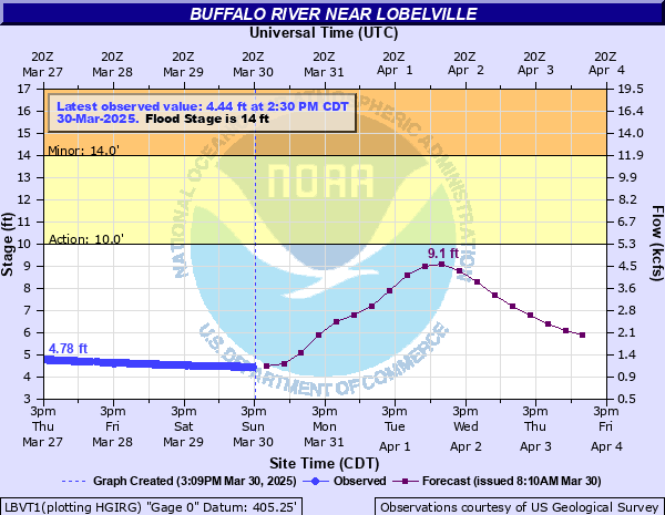
Buffalo River near Lobelville
Critical Stages
10' - Action
14' - Flood
18' - Moderate
22' - Major
Latest Observation
Updated: 11:30 PM CST 12/4/25
Status: No Flooding
Stage: 4.17 ft
Flow: 0.635 kcfs
Forecast
| Time | Stage (ft) | Flow (kcfs) |
|---|---|---|
| 6 AM 12/5 | 4.2 | 0.647 |
| 12 PM 12/5 | 4.2 | 0.647 |
| 6 PM 12/5 | 4.1 | 0.605 |
| 12 AM 12/6 | 4.1 | 0.605 |
| 6 AM 12/6 | 4.1 | 0.605 |
| 12 PM 12/6 | 4.1 | 0.605 |
| 6 PM 12/6 | 4.1 | 0.605 |
| 12 AM 12/7 | 4 | 0.563 |
| 6 AM 12/7 | 4 | 0.563 |
| 12 PM 12/7 | 4 | 0.563 |
| 6 PM 12/7 | 4 | 0.563 |
| 12 AM 12/8 | 4 | 0.563 |
| 6 AM 12/8 | 4 | 0.563 |
| 12 PM 12/8 | 3.9 | 0.522 |
| 6 PM 12/8 | 3.9 | 0.522 |
| 12 AM 12/9 | 3.9 | 0.522 |
| 6 AM 12/9 | 3.9 | 0.522 |
| Time | Stage (ft) | Flow (kcfs) |
|---|---|---|
| 11:30 PM 12/4 | 4.17 | 0.635 |
| 11:15 PM 12/4 | 4.16 | 0.631 |
| 11:00 PM 12/4 | 4.16 | 0.631 |
| 10:45 PM 12/4 | 4.16 | 0.631 |
| 10:30 PM 12/4 | 4.17 | 0.635 |
| 10:15 PM 12/4 | 4.16 | 0.631 |
| 10:00 PM 12/4 | 4.17 | 0.635 |
| 9:45 PM 12/4 | 4.16 | 0.631 |
| 9:30 PM 12/4 | 4.17 | 0.635 |
| 9:15 PM 12/4 | 4.16 | 0.631 |
| 9:00 PM 12/4 | 4.16 | 0.631 |
| 8:45 PM 12/4 | 4.17 | 0.635 |
| 8:30 PM 12/4 | 4.16 | 0.631 |
| 8:15 PM 12/4 | 4.17 | 0.635 |
| 8:00 PM 12/4 | 4.17 | 0.635 |
| 7:45 PM 12/4 | 4.17 | 0.635 |
| 7:30 PM 12/4 | 4.17 | 0.635 |
| 7:15 PM 12/4 | 4.17 | 0.635 |
| 7:00 PM 12/4 | 4.17 | 0.635 |
| 6:45 PM 12/4 | 4.16 | 0.631 |
| 6:30 PM 12/4 | 4.17 | 0.635 |
| 6:15 PM 12/4 | 4.17 | 0.635 |
| 6:00 PM 12/4 | 4.17 | 0.635 |
| 5:45 PM 12/4 | 4.18 | 0.639 |
| 5:30 PM 12/4 | 4.16 | 0.631 |
| 5:15 PM 12/4 | 4.17 | 0.635 |
| 5:00 PM 12/4 | 4.17 | 0.635 |
| 4:45 PM 12/4 | 4.16 | 0.631 |
| 4:30 PM 12/4 | 4.15 | 0.627 |
| 4:15 PM 12/4 | 4.16 | 0.631 |
32' -
Water approaches Interstate 40 east of the river and may be impacted at higher levels.
30' -
State Hwy 13 near Comer Hollow, at King Branch Rd, and just north of Gilmer Bridge Rd is impassable, as well as Jones Hollow Rd at Cane Creek. Many properties are impacted, including those near the intersection of Upper Brush Creek Rd and Godwin Rd in Vaughan Hollow, on Bakerville Rd at Sycamore Landing Rd, and commercial properties at the intersection of State Hwy 13 and Hwy 412 in Linden.
28' -
Extensive flooding continues along the river with portions of State Hwy 13 near Comer Hollow, at King Branch Rd, and just north of Gilmer Bridge Rd flooded and impassable. Water impacts properties near the intersection of Upper Brush Creek Rd and Godwin Rd in Vaughan Hollow, on Bakerville Rd at Sycamore Landing Rd, and commercial properties at the intersection of State Hwy 13 and Hwy 412 in Linden. Water may back up Cane Creek and approach Jones Hollow Rd.
26' -
Extensive flooding is occurring along the river from Linden, to Beardstown, Lobelville, and Bakerville, with flood waters approaching portions of State Hwy 13 near Comer Hollow, at King Branch Rd, and just north of Gilmer Bridge Rd. Water reaches properties near the intersection of Upper Brush Creek Rd and Godwin Rd in Vaughan Hollow, properties on Bakerville Rd at Sycamore Landing Rd, and approaches commercial properties at the intersection of State Hwy 13 and Hwy 412 in Linden.
24' -
Widespread flooding continues to impact areas along the river from Linden, to Beardstown, Lobelville, and Bakerville. Many roads near the river are flooded, including Hwy 438 near Billy Carlton Rd, and Upper Brush Creek Rd west of Vaughan Hollow. Water reaches properties in Bakerville, and approaches properties near the intersection of Upper Brush Creek Rd and Godwin Rd in Vaughan Hollow.
22' -
Widespread flooding is occurring along the river from Linden, to Beardstown, Lobelville, and Bakerville, impacting many roads including Old State Hwy 13, Gilmer Bridge Rd – Lost Creek Rd, Cuba Landing Rd, Squeeze Bottom Rd, and Hwy 438 near Billy Carlton Rd. Water covers Upper Brush Creek Rd west of Vaughan Hollow and is impassable, and water approaches properties in Bakerville.
20' -
Significant flooding continues to impact adjacent areas and roads along the river including Old State Hwy 13, Gilmer Bridge Rd – Lost Creek Rd, Cuba Landing Rd, Squeeze Bottom Rd, and Hwy 438 near Billy Carlton Rd. Waterfront properties off E 8th Ave in Leeper Bottom are also impacted, and water approaches Upper Brush Creek Rd west of Vaughan Hollow.
18' -
Significant flooding is occurring along the river, impacting adjacent areas and roads including Old State Hwy 13 south of School House Rd, Gilmer Bridge Rd – Lost Creek Rd, Cuba Landing Rd and Squeeze Bottom Rd. Water continues to impact waterfront properties off E 8th Ave in Leeper Bottom and approaches Hwy 438 near Billy Carlton Rd in Beardstown.
16' -
Flooding continues to impact agricultural land and properties along the river including Dailey Loop, Caruthers Trace Lane, Lost Creek Rd near Gilmer Bridge Rd, and portions of the Buffalo River Country Club. Water covers Old State Hwy 13 south of School House Rd and Gilmer Bridge Rd – Lost Creek Rd which are impassable. Water begins to impact waterfront properties off E 8th Ave in Leeper Bottom and approaches Cuba Landing Rd and Squeeze Bottom Rd.
14' -
Flooding begins along the river, impacting agricultural land and adjacent properties including Dailey Loop, Caruthers Trace Lane, Lost Creek Rd near Gilmer Bridge Rd, and portions of the Buffalo River Country Club. Water reaches Old State Hwy 13 south of School House Rd and is impassable, and approaches Gilmer Bridge Rd – Lost Creek Rd.
12' -
Water continues to inundate low lying areas and agricultural land along the river, and covers portions of Dailey Loop and Caruthers Trace Lane. Water also approaches Old State Hwy 13 south of School House Rd, and begins to impact properties on Lost Creek Rd near Gilmer Bridge Rd and portions of the Buffalo River Country Club.
10' -
Water begins to inundate low lying areas and agricultural land along the river, and begins to cover portions of Dailey Loop and Caruthers Trace Lane.
| Date | Stage (ft) |
|---|---|
| May 2, 2010 | 26 |
| May 28, 1991 | 25.23 |
| May 8, 2003 | 21.45 |
| Mar 23, 1955 | 20.4 |
| Feb 16, 2003 | 20.3 |
| Jan 25, 2002 | 20.27 |
| Feb 20, 1991 | 20.2 |
| Dec 3, 1991 | 20.16 |
| Mar 14, 1975 | 20.1 |
| Feb 24, 2019 | 19.91 |
| Mar 28, 2021 | 19.41 |
| Mar 17, 1973 | 19.4 |
| Mar 2, 2018 | 19.36 |
| Dec 1, 2001 | 19.23 |
| Feb 7, 2004 | 19.13 |
| Feb 5, 1990 | 18.99 |
| Feb 5, 1990 | 18.99 |
| Mar 4, 1997 | 18.8 |
| Feb 24, 2022 | 18.78 |
| Dec 10, 1972 | 18.7 |
Data provided by the National Weather Service.