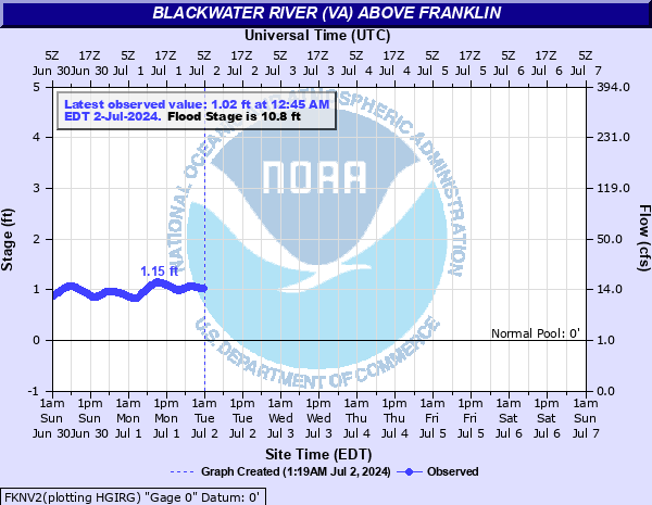
Blackwater River (VA) above Franklin
Critical Stages
6.8' - Action
10.8' - Flood
14.8' - Moderate
18.8' - Major
Latest Observation
Updated: 8:45 AM EST 12/6/25
Status: No Flooding
Stage: 4.3 ft
Flow: 0.284 kcfs
Forecast
Forecast not available for this location.
| Time | Stage (ft) | Flow (kcfs) |
|---|---|---|
| 8:45 AM 12/6 | 4.3 | 0.284 |
| 8:30 AM 12/6 | 4.3 | 0.284 |
| 8:15 AM 12/6 | 4.3 | 0.284 |
| 8:00 AM 12/6 | 4.3 | 0.284 |
| 7:45 AM 12/6 | 4.3 | 0.284 |
| 7:30 AM 12/6 | 4.3 | 0.284 |
| 7:15 AM 12/6 | 4.29 | 0.282 |
| 7:00 AM 12/6 | 4.29 | 0.282 |
| 6:45 AM 12/6 | 4.29 | 0.282 |
| 6:30 AM 12/6 | 4.29 | 0.282 |
| 6:15 AM 12/6 | 4.29 | 0.282 |
| 6:00 AM 12/6 | 4.29 | 0.282 |
| 5:45 AM 12/6 | 4.29 | 0.282 |
| 5:30 AM 12/6 | 4.29 | 0.282 |
| 5:15 AM 12/6 | 4.28 | 0.281 |
| 5:00 AM 12/6 | 4.28 | 0.281 |
| 4:45 AM 12/6 | 4.28 | 0.281 |
| 4:30 AM 12/6 | 4.28 | 0.281 |
| 4:15 AM 12/6 | 4.28 | 0.281 |
| 4:00 AM 12/6 | 4.28 | 0.281 |
| 3:45 AM 12/6 | 4.27 | 0.279 |
| 3:30 AM 12/6 | 4.27 | 0.279 |
| 3:15 AM 12/6 | 4.27 | 0.279 |
| 3:00 AM 12/6 | 4.27 | 0.279 |
| 2:45 AM 12/6 | 4.27 | 0.279 |
| 2:30 AM 12/6 | 4.27 | 0.279 |
| 2:15 AM 12/6 | 4.26 | 0.278 |
| 2:00 AM 12/6 | 4.26 | 0.278 |
| 1:45 AM 12/6 | 4.26 | 0.278 |
| 1:30 AM 12/6 | 4.26 | 0.278 |
30' -
River stage sensor operating limit
25.11' -
Flood of record during Hurricane Floyd
20.8' -
2nd and Mechanic Streets flooded, Bowers Road residences flooded.
19.8' -
Flooded up to the corner of Main and 2nd Streets.
18.84' -
Major flooding begins.
15.43' -
Stage of the 25-year flood.
14.8' -
Moderate flooding, access road to water treatment plant begins to floods.
12.3' -
A portion of State Route 611, Joyners Bridge Road, in Isle of Wight County is flooded.
11.8' -
A portion of State Route 611 in Southampton County, Joyners Bridge Road, is innundated. A portion of State Route 619, in Isle of Wight County, is flooded.
10.8' -
A portion of Barretts Landing River Walk is innundated in Downtown Franklin area.
| Date | Stage (ft) |
|---|---|
| Sep 18, 1999 | 25.11 |
| Oct 10, 2006 | 21.61 |
| Aug 19, 1940 | 20.84 |
| Mar 10, 1944 | 16.11 |
| Sep 14, 1960 | 15.98 |
| Sep 21, 2003 | 15.63 |
| Oct 10, 2016 | 15.51 |
| Feb 9, 1943 | 14.49 |
| Sep 20, 2020 | 14.49 |
| Sep 4, 2006 | 14.45 |
| Feb 7, 1998 | 14.11 |
| Jun 6, 1963 | 13.81 |
| Aug 31, 2011 | 13.57 |
| Nov 14, 2020 | 13.49 |
| Apr 13, 2003 | 13.26 |
| Sep 12, 2011 | 13.15 |
| Jun 12, 2013 | 13.07 |
| Mar 22, 1975 | 13.05 |
| Aug 19, 2020 | 12.78 |
| Mar 5, 1994 | 12.67 |
Data provided by the National Weather Service.